Chřibská
| Chřibská | |||
| Town | |||
|
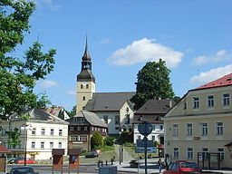
Square with St. George Church and birth house of Thaddäus Haenke (far right)
|
|||
|
|||
| Country | Czech Republic | ||
|---|---|---|---|
| Region | Ústí nad Labem | ||
| District | Děčín | ||
| Commune | Varnsdorf | ||
| Elevation | 387 m (1,270 ft) | ||
| Coordinates | 50°51′44″N 14°28′53″E / 50.86222°N 14.48139°ECoordinates: 50°51′44″N 14°28′53″E / 50.86222°N 14.48139°E | ||
| Area | 15.93 km2 (6.15 sq mi) | ||
| Population | 1,407 | ||
| Density | 88/km2 (228/sq mi) | ||
| First mentioned | 1383 | ||
| Mayor | Jan Machač | ||
| Timezone | CET (UTC+1) | ||
| - summer (DST) | CEST (UTC+2) | ||
| Postal code | 407 44 | ||
| Statistics: statnisprava.cz | |||
| Website: www.chribska.cz | |||
Chřibská (Czech pronunciation: [ˈxr̝̊ɪpskaː]; German: Kreibitz) is a town in the Okres Děčín in Ústí nad Labem Region of the Czech Republic. It has c. 1407 inhabitants (2005).
The place was first mentioned in 1383 as located at the trading road from Bohemia to the Lausitz. It became part of the possessions of the family of Wartenberg from Děčín, and in 1614 of the Kinsky family. Town rights had been granted in 1570, and in 1596 a militia was founded for defense.
Until 1918, KREIBITZ was part of the Austrian monarchy (Austria side after the compromise of 1867), in the RUMBURG (Rumburk) district, one of the 94 Bezirkshauptmannschaften in Bohemia.
Along with other parts of the former Austrian Empire, Chřibská became part of Czechoslovakia in 1919. From 1938, after the Munich Agreement regarding the Sudetenland, until 1945, Chřibská was part of Varnsdorf district, with the suburbs of Niederkreibitz (Dolní Chřibská), Oberkreibitz (Horní Chřibská) and Schönfeld (Krásné Pole).
The Expulsion of Germans after World War II in 1945-1946 reduced the population (see the Beneš decrees).
...
Wikipedia


