Certara
| Certara | ||
|---|---|---|
| Former municipality of Switzerland | ||
|
||
| Coordinates: 46°5′N 9°4′E / 46.083°N 9.067°ECoordinates: 46°5′N 9°4′E / 46.083°N 9.067°E | ||
| Country | Switzerland | |
| Canton | Ticino | |
| District | Lugano | |
| Area | ||
| • Total | 2.73 km2 (1.05 sq mi) | |
| Elevation | 1,025 m (3,363 ft) | |
| Population (Dec 2011) | ||
| • Total | 60 | |
| • Density | 22/km2 (57/sq mi) | |
| Postal code | 6959 | |
| SFOS number | 5173 | |
| Surrounded by | Bogno, Cimadera, Valcolla, Val Rezzo (IT-CO) | |
| Website | SFSO statistics |
|
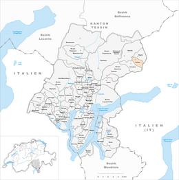
Certara is a former municipality in the district of Lugano in the canton of Ticino in Switzerland. On 14 April 2013 the former municipalities of Bogno, Cadro, Carona, Certara, Cimadera, Valcolla and Sonvico merged into the municipality of Lugano.
Certara is first mentioned in 1264 as Certara with the church of S. Pietro Martire.
Certara was probably originally a simple alpine herding camp for the village of Sonvico. Although the village remained dependent, until 1899, on the parish of St. Pietro in Colla, it already had its own property in 1591, a cemetery in the 17th Century, the Baptistery of S. Rocco in 1670 and also a pastor.
The income of the village came mainly from agriculture and cattle breeding but was supplemented by the money sent back to the village by emigrants. Starting in the late 19th Century, the village population declined as a result of the decline of agriculture and the formation of the Lugano agglomeration. Today, many houses are used as second or vacation homes.
Before the merger, Certara had a total area of 2.7 km2 (1.0 sq mi). Of this area, 0.19 km2 (0.073 sq mi) or 7.0% is used for agricultural purposes, while 2.22 km2 (0.86 sq mi) or 81.3% is forested. Of the rest of the land, 0.12 km2 (30 acres) or 4.4% is settled (buildings or roads) and 0.09 km2 (22 acres) or 3.3% is unproductive land.
Of the built up area, housing and buildings made up 1.1% and transportation infrastructure made up 3.3%. Out of the forested land, 76.9% of the total land area is heavily forested and 4.0% is covered with orchards or small clusters of trees. Of the agricultural land, 5.9% is used for growing crops and 1.1% is used for alpine pastures.
The municipality is located in the Lugano district, on the left side of the Val Colla between two mountains, Denti della Vecchia and the village Gazzirola on il Gazzirola at the Italian border.
...
Wikipedia


