Cerro Colorado (volcano)
| Cerro Colorado | |
|---|---|

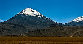
The Cerro Colorado volcano, seen from the west. The right, part of volcán Escalante (El Apagado)
|
|
| Highest point | |
| Elevation | 5,748 m (18,858 ft) |
| Coordinates | 22°35.54′S 67°55.33′W / 22.59233°S 67.92217°WCoordinates: 22°35.54′S 67°55.33′W / 22.59233°S 67.92217°W |
| Geography | |
| Location | Chile |
| Parent range | Andes |
| Geology | |
| Mountain type | Stratovolcano |
Cerro Colorado is a stratovolcano that lies in northern Chile about 7 km (4 mi) west of the border with Bolivia and approximately the same distance southwest of the Putana Volcano. Cerro Colorado is located immediately west of Cerro Curiquinca and northwest of volcán Escalante (El Apagado); all three mountains are considered to be part of the Sairecabur volcanic group.
...
Wikipedia
