Cementon, Pennsylvania
| Cementon | |
|---|---|
| census-designated place | |
 |
|
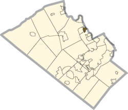
 Location within Lehigh county |
|
| Location within the state of Pennsylvania | |
| Coordinates: 40°41′55″N 75°30′1″W / 40.69861°N 75.50028°WCoordinates: 40°41′55″N 75°30′1″W / 40.69861°N 75.50028°W | |
| Country | United States |
| State | Pennsylvania |
| County | Lehigh |
| Township | Whitehall |
| Population (2010) | |
| • Total | 1,538 |
| Time zone | Eastern (EST) (UTC-5) |
| • Summer (DST) | EDT (UTC-4) |
| ZIP codes | 18052 |
| Area code(s) | 610 & 484 |
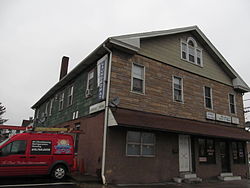
Cementon is an census-designated place located in Lehigh County, Pennsylvania, in the United States. The town is in Whitehall Township, 7 miles (11 km) north of Allentown and 1 mile (1.6 km) east of Egypt. Cementon is situated along the Lehigh River, just across from the borough of Northampton. Cementon is located on Pennsylvania Route 329, just east of its intersection with Pennsylvania Route 145 at Eagle Point. The population of Cementon is 1,538. It uses the Whitehall zip code of 18052.
Cementon was originally known as Siegfried's Ferry, as it is located directly across the Lehigh River from Siegfried (one of the three villages that would merge to become Northampton in 1902). In 1828, a bridge was built across the river, and the town became known as Siegfried's Bridge. After a large Whitehall Portland Cement Works' quarry and mill were established in 1900/1901, the town was renamed Cementon.
Cementon is part of the Whitehall-Coplay School District. Students in grades nine through 12 attend Whitehall High School.
...
Wikipedia

