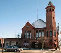
Celina, Ohio
| Celina, Ohio | |
|---|---|
| City | |

City Hall
|
|
| Nickname(s): C-Town | |
| Motto: "One Of The 100 Best Small Towns!" | |
 Location in Mercer County and the state of Ohio. |
|
| Coordinates: 40°33′5″N 84°34′12″W / 40.55139°N 84.57000°WCoordinates: 40°33′5″N 84°34′12″W / 40.55139°N 84.57000°W | |
| Country | United States |
| State | Ohio |
| County | Mercer |
| Government | |
| • Mayor | Jeffrey Hazel |
| Area | |
| • Total | 5.27 sq mi (13.65 km2) |
| • Land | 4.98 sq mi (12.90 km2) |
| • Water | 0.29 sq mi (0.75 km2) |
| Elevation | 876 ft (267 m) |
| Population (2010) | |
| • Total | 10,400 |
| • Estimate (2012) | 10,395 |
| • Density | 2,088.4/sq mi (806.3/km2) |
| Time zone | Eastern (EST) (UTC-5) |
| • Summer (DST) | EDT (UTC-4) |
| ZIP codes | 45822, 45826 |
| Area code(s) | 419 |
| FIPS code | 39-12868 |
| GNIS feature ID | 1048589 |
| Website | City of Celina, Ohio |
Celina (/səˈlaɪnə/ sə-LY-nə) is a city in and the county seat of Mercer County, Ohio, United States. The population was 10,400 at the 2010 census. Celina is situated on the western shores of Grand Lake St. Marys.
James Watson Riley established Celina in 1834. The settlement was named after Salina, New York.
Celina is located at 40°33′5″N 84°34′12″W / 40.55139°N 84.57000°W (40.551459, -84.570057), at an elevation of 886 feet (270 m). According to the United States Census Bureau, the city has a total area of 5.27 square miles (13.65 km2), of which 4.98 square miles (12.90 km2) is land and 0.29 square miles (0.75 km2) is water.
As of the census of 2000, there were 10,303 people, 4,191 households, and 2,745 families residing in the city. The population density was 2,346.9 people per square mile (906.2/km²). There were 4,466 housing units at an average density of 1,017.3/sq mi (392.8/km²). The racial makeup of the city was 97.04% White, 0.18% African American, 0.37% Native American, 0.67% Asian, 0.02% Pacific Islander, 0.62% from other races, and 1.10% from two or more races. Hispanic or Latino of any race were 2.14% of the population.
...
Wikipedia
