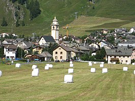
Celerina, Switzerland
| Celerina/Schlarigna | ||
|---|---|---|
 |
||
|
||
| Coordinates: 46°31′N 9°52′E / 46.517°N 9.867°ECoordinates: 46°31′N 9°52′E / 46.517°N 9.867°E | ||
| Country | Switzerland | |
| Canton | Graubünden | |
| District | Maloja | |
| Area | ||
| • Total | 24.02 km2 (9.27 sq mi) | |
| Elevation | 1,714 m (5,623 ft) | |
| Population (Dec 2015) | ||
| • Total | 1,534 | |
| • Density | 64/km2 (170/sq mi) | |
| Postal code | 7505 | |
| SFOS number | 3782 | |
| Surrounded by | Pontresina, Samedan, Sankt-Moritz | |
| Website |
www SFSO statistics |
|
Celerina/Schlarigna (German/Italian Celerina; Romansh ![]() Schlarigna ) is a municipality in the Maloja Region in the Swiss canton of Graubünden.
Schlarigna ) is a municipality in the Maloja Region in the Swiss canton of Graubünden.
Celerina/Schlarigna is first mentioned in 1313 as Schellarin. In 1320 it was mentioned as Celarina.
Celerina/Schlarigna has an area, as of 2006[update], of 24 km2 (9.3 sq mi). Of this area, 34% is used for agricultural purposes, while 30.5% is forested. Of the rest of the land, 4.1% is settled (buildings or roads) and the remainder (31.4%) is non-productive (rivers, glaciers or mountains).
It consists of the haufendorf village (an irregular, unplanned and quite closely packed village, built around a central square) of Celerina/Schlarigna and the hamlet of Crasta. in the Oberengadin sub-district of the Maloja district, after 2017 it was part of the Maloja Region. The municipality's official name used to be Celerina, until 1943, when it adopted the name Schlarigna/Celerina. In 1950, it was renamed again to Celerina/Schlarigna.
It is located in the upper Engadin valley in the Oberengadin sub-district of the Maloja district and is across from the entrance of the Bernina Pass into the Engadin. The village is located between St. Moritz, Samedan and Pontresina. The famous Cresta Run for tobogganing leads from St.Moritz to the Cresta neighborhood of Celerina.
...
Wikipedia


