Cedarville, Ohio
| Cedarville, Ohio | |
|---|---|
| Village | |

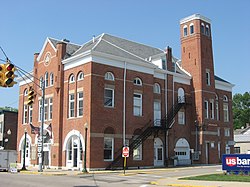
Cedarville's historic opera house
|
|
 Location of Cedarville, Ohio |
|
 Location of Cedarville in Greene County |
|
| Coordinates: 39°44′34″N 83°48′26″W / 39.74278°N 83.80722°WCoordinates: 39°44′34″N 83°48′26″W / 39.74278°N 83.80722°W | |
| Country | United States |
| State | Ohio |
| County | Greene |
| Government | |
| • Mayor | Robert Fudge |
| Area | |
| • Total | 1.32 sq mi (3.42 km2) |
| • Land | 1.28 sq mi (3.32 km2) |
| • Water | 0.04 sq mi (0.10 km2) |
| Elevation | 1,050 ft (320 m) |
| Population (2010) | |
| • Total | 4,019 |
| • Estimate (2012) | 4,032 |
| • Density | 3,000/sq mi (1,200/km2) |
| Time zone | Eastern (EST) (UTC-5) |
| • Summer (DST) | EDT (UTC-4) |
| ZIP code | 45314 |
| Area code(s) | 937 |
| FIPS code | 39-12784 |
| GNIS feature ID | 1056780 |
| Website | cedarvilleohio.net |
Cedarville is a village in Greene County, Ohio, United States. The population was 4,019 at the 2010 census. It is the home of Cedarville University and Cedarville High School.
Cedarville is part of the Dayton Metropolitan Statistical Area. It is served by a branch of the Greene County Public Library.
Cedarville was originally known as Milford, and under the latter name was platted in 1816. A post office called Massies Creek was established in 1837, and the name was changed to Cedarville in 1843. The present name is for cedar trees near the original town site.
For many years beginning in the 1880s, public life in Cedarville centered around the downtown Cedarville Opera House; it survives to the present day, and is listed on the National Register of Historic Places.
Cedarville is located at 39°44′34″N 83°48′26″W / 39.74278°N 83.80722°W (39.742796, -83.807084). According to the United States Census Bureau, the village has a total area of 1.32 square miles (3.42 km2), of which 1.28 square miles (3.32 km2) is land and 0.04 square miles (0.10 km2) is water.
...
Wikipedia
