Cedars of Lebanon State Park
| Cedars of Lebanon State Park | |
|---|---|

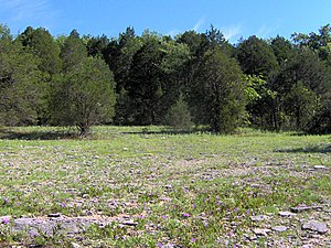
cedar glade
|
|
| Type | Tennessee State Park |
| Location | Lebanon, Tennessee |
| Coordinates | 36°04′25″N 86°18′41″W / 36.07366°N 86.31151°WCoordinates: 36°04′25″N 86°18′41″W / 36.07366°N 86.31151°W |
| Area | 900 acres (364 ha) |
| Operated by | Tennessee Department of Environment and Conservation |
|
Cedars of Lebanon State Park Historic District
|
|

Cedar Lodge
|
|
| Nearest city | Lebanon, Tennessee |
| Built | 1925-1949 |
| NRHP Reference # | 95001274 |
| Added to NRHP | 1995 |
Cedars of Lebanon State Park is a state park in Wilson County, Tennessee, in the southeastern United States. It consists of 900 acres (364 ha) situated amidst the 9,420-acre (3,810 ha) Cedars of Lebanon State Forest. The park and forest are approximately 10 miles (16 km) south of Lebanon, Tennessee.
Cedars of Lebanon State Forest is known for its cedar glades, a unique type of ecosystem that has adapted to the thin (or nonexistent) soil layers that often occur in the eastern Central Basin. These glades are typically flanked by thick stands of red cedar, a type of juniper tree that can survive in soil layers too thin to support most large wooded plants. The presence of the red cedar in the basin reminded the region's early Euro-American settlers of the Lebanese cedar forests of Biblical fame.
Cedars of Lebanon State Park is situated in the eastern Central Basin approximately 15 miles (24 km) west of the eastern Highland Rim, 15 miles (24 km) east of Nashville and 20 miles (32 km) north of Murfreesboro. U.S. Route 231, which runs north-to-south, splits the state forest into eastern and western sections. The state park (i.e., the developed area) is located in the eastern section along Cedar Forest Road. The western section consists of an undeveloped state forest. 1,043 acres (422 ha) of the western section has been classified as a state natural area.
Like most karst areas, Cedars of Lebanon State Forest is drained in large part by underground streams. The water in the forest probably ends up in nearby streams, such as Hurricane Creek. These streams empty into the Stones River's J. Percy Priest Lake impoundment, which is located just a few miles to the west.
Cedars of Lebanon State Forest is underlain by Ordovician period limestone, formed roughly 460 million years ago from calcareous ooze deposited by a primordial sea that once covered Middle Tennessee. Weathering of this rock has led to the creation of karst formations such as joints, underground streams, caves, and sinkholes, which are common throughout the park and forest. The forest is located in a flat section of the Central Basin characterized by thin soil layers where the limestone bedrock is often exposed.
...
Wikipedia
