Stones River
| Stones River | |
|---|---|

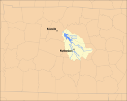
Map of the Stones River Watershed
|
|
| Country | United States |
| Basin features | |
| Main source | East Fork - Short Mountain, Cannon County, TN----Middle Fork - Hoovers Gap, Rutherford County, TN----West Fork - Tennessee Valley Divide in Rutherford County, TN East Fork - 1,120 feet (341.4 m) Middle Fork - 923 feet (281.3 m) West Fork - 792 feet (241.4 m) |
| River mouth |
Cumberland River near Nashville, TN 385 feet (117.3 m) |
| Basin size | 921 square miles (2,385.4 km2) |
| Physical characteristics | |
| Length | Main River - 32.4 miles (52.1 km) East Fork - 54.0 miles (86.9 km) Middle Fork - 19.8 miles (31.9 km) West Fork - 39.1 miles (62.9 km) |
The Stones River (properly spelled Stone's River) is a major stream of the eastern portion of Tennessee's Nashville Basin region. It is named after explorer and longhunter Uriah Stone, who navigated the river in 1767.
The Stones River is composed of three major forks: the West, Middle, and East forks. The West Fork, 39.1 miles (62.9 km) long, rises in southernmost Rutherford County near the Bedford County line. The upstream portion of its course runs roughly parallel to U.S. Highway 231. The Middle Fork, 19.8 miles (31.9 km) long, rises in an area of low hills, or knobs, also near the line with Bedford County, near Hoovers Gap, an important troop movement route during the American Civil War. It flows roughly parallel to, but west of, Interstate 24 and U.S. Highway 41, and is met by the West Fork near State Route 99. The East Fork is the longest, at 54.0 miles (86.9 km); it rises in Cannon County on Short Mountain, an outlier of the Cumberland Plateau, and flows through Woodbury, the county seat. This stream is roughly paralleled by U.S. Route 70S.
The West Fork runs just west of downtown Murfreesboro. Just northwest of Murfreesboro along the West Fork is the Stones River National Battlefield, site of the Battle of Stones River, a major Civil War battle that was fought from December 31, 1862, to January 2, 1863. The East Fork runs well to the north of Murfreesboro, adjacent to the grounds of the Alvin C. York Veterans Affairs hospital, and is crossed by U.S. Highway 231 near the community of Walterhill, site of a former hydroelectric dam used for a power supply for the surrounding area prior to the advent of the Tennessee Valley Authority. Near this site is a gigantic landfill operated by Browning-Ferris Industries.
...
Wikipedia
