Cedarburg, Wisconsin
| City of Cedarburg, Wisconsin | |
|---|---|
| City | |

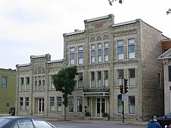
Washington Avenue Historic District in downtown Cedarburg
|
|
 Location of Cedarburg, Wisconsin |
|
| Coordinates: 43°17′18″N 87°59′15″W / 43.28833°N 87.98750°WCoordinates: 43°17′18″N 87°59′15″W / 43.28833°N 87.98750°W | |
| Country | United States |
| State | Wisconsin |
| County | Ozaukee |
| Government | |
| • Type | Mayor/Council |
| • Mayor | Kip Kinzel (R) |
| Area | |
| • Total | 4.87 sq mi (12.61 km2) |
| • Land | 4.83 sq mi (12.51 km2) |
| • Water | 0.04 sq mi (0.10 km2) |
| Elevation | 784 ft (239 m) |
| Population (2010) | |
| • Total | 11,412 |
| • Estimate (2012) | 11,435 |
| • Density | 2,362.7/sq mi (912.2/km2) |
| Time zone | Central (CST) (UTC-6) |
| • Summer (DST) | CDT (UTC-5) |
| Zip Code | 53012 |
| Area code(s) | 262 |
| FIPS code | 55-13375 |
| GNIS feature ID | 1562869 |
| Website | ci.cedarburg.wi.us |
Cedarburg is a city in Ozaukee County, Wisconsin, United States. It is located about 20 miles (32 km) north of Milwaukee and near the shores of Lake Michigan. The city is bordered by the village of Grafton to the east and the Town of Cedarburg elsewhere. The population was 11,412 at the 2010 census.
The first person to settle in the area was Joseph Gardenier, who built a log shanty on Cedar Creek, in what is now Hamilton. The shanty was his headquarters for surveying for the construction of the Green Bay Road. William Ludwig Groth (Ludwig Groth) is usually credited with being the first settler. He purchased land from the government on October 22, 1842, and began platting the banks of Cedar Creek. Frederick August Leuning, who immigrated to the area in 1843, built a cabin near Cedar Creek on what was later the east end of the city. He called the cabin "Cedarburg", which meant "the castle of cedars". Soon afterwards, he built the Columbia Mill on that site. In December 1844 it was agreed that the town be named Cedarburg. Groth envisioned a village along Cedar Creek and parceled out his land for those who would in the future build businesses and settle permanently. Groth eventually included all of north Cedarburg, everything above the interurban tracks to Bridge St. and from 3rd St. to Jefferson Ave. His untimely death in 1850 kept him from continuing land developments.
In 1845, Frederick Hilgen and William Schroeder saw what Groth had envisioned. After writing to Hilgen's brother-in-law, C. Frederick Boerner, they found financing for further development. Boerner loaned Hilgen and Schroeder thousands of dollars at half the going rate to develop the village of Cedarburg. They had built a gristmill on Cedar Creek. After eleven years of operation, they replaced the original structure with the five-story, stone Cedarburg Mill, which became the focal point of the new community. Five dams and mills were eventually built along the creek in what are now the city and town of Cedarburg. The Hilgen Spring Park, begun in 1854, was a 74-acre (300,000 m2) resort, that attracted visitors from all over the Midwest.
...
Wikipedia
