Caverna do Diabo State Park
| Caverna do Diabo State Park | |
|---|---|
| Parque Estadual Caverna do Diabo | |
|
IUCN category II (national park)
|
|

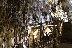
Walkway in the Caverna da Tapagem
|
|
| Nearest city | Barra do Turvo, São Paulo |
| Coordinates | 24°39′36″S 48°27′17″W / 24.659955°S 48.454678°WCoordinates: 24°39′36″S 48°27′17″W / 24.659955°S 48.454678°W |
| Area | 40,174.82 hectares (99,274.1 acres) |
| Designation | State park |
| Created | 21 February 2008 |
| Administrator | Fundação Florestal SP |
The Caverna do Diabo State Park (Portuguese: Parque Estadual Caverna do Diabo) is a state park in the state of São Paulo, Brazil, established in 2008. It protects a mountainous area of Atlantic Forest, and is known for the dramatic Caverna da Tapagem or Caverna do Diabo, which draws thousands of visitors each year.
The Caverna do Diabo State Park is divided between the municipalities of Barra do Turvo, Cajati, Eldorado and Iporanga in São Paulo. It has an area of 40,174.82 hectares (99,274.1 acres). The Caverna do Diabo State Park was created by state law 12.810 of 21 February 2008. It was one of several conservation units created by law 12.810 in which the Jacupiranga Mosaic was created from the former Jacupiranga State Park and its surrounding lands. The park was created to preserve the Atlantic Forest biome.
The park forms part of the Serra de Paranapiacaba Mosaic, which has over 120,000 hectares (300,000 acres) and contains the largest remaining area of Atlantic Forest in Brazil. Other conservation units in the mosaic are the Carlos Botelho State Park, Alto Ribeira Tourist State Park, Nascentes do Paranapanema State Park, Intervales State Park, Xitué Ecological Station, Serra do Mar Environmental Protection Area and Quilombos do Médio Ribeira Environmental Protection Area.
...
Wikipedia

