Catubig
| Catubig | |
|---|---|
| Municipality | |
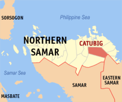
 Map of Northern Samar showing the location of Catubig. |
|
| Location within the Philippines | |
| Coordinates: 12°24′N 125°03′E / 12.400°N 125.050°ECoordinates: 12°24′N 125°03′E / 12.400°N 125.050°E | |
| Country |
|
| Region | Eastern Visayas (Region VIII) |
| Province | Northern Samar |
| Barangays | 47 |
| Government | |
| • Mayor | Galahad O. Vicencio |
| • Vice Mayor | Jesusimo Jr. Manlangit |
| Area | |
| • Total | 214.99 km2 (83.01 sq mi) |
| Population (2015) | |
| • Total | 33,025 |
| • Density | 150/km2 (400/sq mi) |
| Demonym(s) | Catubignon |
| Time zone | PST (UTC+8) |
| ZIP code | 6418 |
| IDD : area code | 55 |
| Income class | 3rd Class |
Catubig is a third class municipality in the province of Northern Samar, Philippines. According to the 2015 census, it has a population of 33,025 people.
During the Philippine–American War, Catubig was the scene of a battle between the warays and the Americans known as the Siege of Catubig. The Siege of Catubig was fought for four days beginning April 15, 1900.
Catubig is politically subdivided into 47 barangays.
...
Wikipedia

