Catonsville, MD
| Catonsville, Maryland | |
|---|---|
| Census-designated place | |

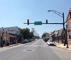
Frederick Road in Downtown Catonsville.
|
|
| Nickname(s): "Music City, Maryland", "Cville", "Satansville" | |
| Motto: "Life is great in 21228" | |
 Location of Catonsville, Maryland |
|
| Coordinates: 39°16′26″N 76°44′17″W / 39.27389°N 76.73806°WCoordinates: 39°16′26″N 76°44′17″W / 39.27389°N 76.73806°W | |
| Country | United States |
| State |
|
| County |
|
| Area | |
| • Total | 14.0 sq mi (36.3 km2) |
| • Land | 14.0 sq mi (36.3 km2) |
| • Water | 0.0 sq mi (0.0 km2) |
| Elevation | 479 ft (146 m) |
| Population (2010) | |
| • Total | 41,567 |
| • Density | 3,000/sq mi (1,100/km2) |
| Time zone | Eastern (EST) (UTC-5) |
| • Summer (DST) | EDT (UTC-4) |
| ZIP codes | 21228, 21229, 21250 |
| Area code(s) | 410 |
| FIPS code | 24-14125 |
| GNIS feature ID | 0583624 |
Catonsville is a census-designated place (CDP) in Baltimore County, Maryland, United States. The population was 41,567 at the 2010 census. The community lies to the west of Baltimore along the city's border. Catonsville contains the majority of University of Maryland, Baltimore County (UMBC), a major public research university with close to 14,000 students.
Europeans were the second group to settle the area now known as Catonsville. It is generally believed by historians that native tribes, known as the Piscataway, established villages here before the European colonists arrived. This tribe occupied the land between the Potomac River and Chesapeake Bay and up the Patapsco River. Catonsville was located along the Piscataway Trail. The colonists and the tribes got along until the mid-17th century, when the English government ended the practices of Catholic missionaries in the area. It is believed that the tribes were driven from their villages and some were hunted by slave catchers. As happened in many areas of early colonial America, diseases unknown to the tribes were spread by the colonists. Eventually, the tribes moved north under the protection of the Iroquois.
With most of the natives scattered, the colonists expanded across Maryland. Present-day Catonsville was settled in the 18th century. In the early 19th century, a county road along the Patapsco River—named the Frederick Turnpike, later designated Route 144—was opened by the Ellicott family to serve traffic between their flour mill, Ellicott Mills, and Baltimore. Catonsville as we know it today was settled along this route by Richard Caton, under the authority of his father-in-law Charles Carroll, a signer of the Declaration of Independence. Travelers along "the turnpike" (as it was then known) rested and conducted business in the area, causing Catonsville to grow.
...
Wikipedia
