Catlow Valley (Oregon)
| Catlow Valley | |
|
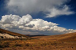
The Catlow Valley from Catlow Valley Road
|
|
| Country | United States |
|---|---|
| State | Oregon |
| County | Harney |
| Part of | Basin and Range Province |
| Borders on | Hart Mountain (west) Steens Mountain/Catlow Rim (east) |
| Elevation | 4,554 ft (1,388 m) |
| Coordinates | 42°33′49″N 119°03′30″W / 42.5634968°N 119.0582564°WCoordinates: 42°33′49″N 119°03′30″W / 42.5634968°N 119.0582564°W |
| Length | 50 mi (80 km), north–south |
| Width | 30 mi (48 km), east–west |
| Area | 1,300 sq mi (3,367 km2) |
The Catlow Valley is a basin in Harney County, Oregon, United States. It is a remote valley at the northwestern corner of North America's Basin and Range Province. The valley is named after a pioneer rancher, John Catlow. The area was used by Native Americans for thousands of years before European explorers arrived in the 19th century. Today, cattle ranching is the main commercial activity in the valley. The public land in the Catlow Valley is administered by the Bureau of Land Management. This public land offers a number of recreational opportunities including hiking, hunting, fishing, bird watching, and wildlife viewing.
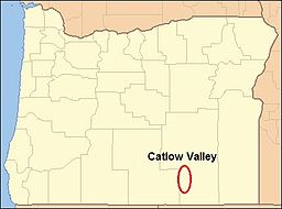
Catlow Valley is located in Harney County in southeastern Oregon. The area is the northwestern corner of North America's continental basin and range country. The valley is approximately 50 miles (80 km) long and 30 miles (48 km) wide. It covers approximately 1,300 square miles (3,400 km2) of high desert range land. The average elevation of the valley floor is 4,500 feet (1,400 m) above sea level.
The Catlow Valley is bounded by Hart Mountain on the west and Steens Mountain on the east, and Beatys Butte is southwest of the valley. Warner Peak is the highest point on Hart Mountain. The summit of Warner Peak is 8,012 feet (2,442 m) above sea level. From the crest of the Hart Mountain, the land slopes gently down to the floor of the valley. Steens Mountain's western boundary is Catlow Rim. The rim runs along the east side of Catlow Valley from north to south. At the north end of the valley, the rim begins as gentle rolling hills. The rim gets steeper and high as it runs south. At the south end of the valley, Catlow Rim has a cliff face that rises more than a 1,000 feet (300 m) above the valley floor. Beatys Butte is a stand-alone peak southwest of Catlow Valley. Its summit is 7,918 feet (2,413 m) above sea level, which gives it a 3,400-foot (1,000 m) prominence above the valley floor.
...
Wikipedia


