Castelo Branco (Horta)
| Castelo Branco | ||
| Civil Parish | ||
|
The International Airport in Castelo Branco and view of the urbanized settlement
|
||
|
||
| Official name: Freguesia do Castelo Branco | ||
| Name origin: Portuguese for white castle | ||
| Country | ||
|---|---|---|
| Autonomous Region | ||
| Island | Faial | |
| Municipality | Horta | |
| Localities | Canada da Santa Catarina, Cancela, Cerrado Grande, Farrobim do Norte, Grota do Meio, Jogo, Lombega, Pedreiras, Ribeira Grande, Ribeirinha | |
| Landmark | Horta International Airport | |
| Rivers | Grota do Meio, Grota do Fundo, Ribeira da Fontinha, Ribeira da Lombega, Ribeira da Santa Catarina, Ribeira Pequena, Ribeira Grande | |
| Center | Canada da Santa Catarina | |
| - elevation | 196 m (643 ft) | |
| - coordinates | 38°32′7″N 28°44′25″W / 38.53528°N 28.74028°WCoordinates: 38°32′7″N 28°44′25″W / 38.53528°N 28.74028°W | |
| Highest point | Caldeira | |
| - location | Lomba do Meio | |
| - elevation | 1,025 m (3,363 ft) | |
| - coordinates | 38°34′33″N 28°43′2″W / 38.57583°N 28.71722°W | |
| Lowest point | Sea level | |
| - location | Atlantic Ocean | |
| - elevation | 0 m (0 ft) | |
| Area | 23.91 km2 (9 sq mi) | |
| - urban | 1.2 km2 (0 sq mi) | |
| Population | 1,309 (2011) | |
| Density | 55/km2 (142/sq mi) | |
| Settlement | 16th century | |
| LAU | Junta Freguesia | |
| President Junta | Luís Felipe Goulart Botelho | |
| Timezone | Azores (UTC-1) | |
| - summer (DST) | Azores (UTC0) | |
| Postal Zone | 9900-323 | |
| Area Code & Prefix | (+351) 292 XX XX XX | |
| Demonym | Albicastrense | |
| Patron Saint | Santa Catarina de Alexandria | |
|
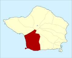
Location of the civil parish of Castelo Branco within the municipality of Horta
|
||
| Website: http://www.castelobranco.org | ||
| Geographic detail from CAOP (2010) produced by Instituto Geográfico Português (IGP) | ||
Castelo Branco is the southern freguesia ("civil parish") on the island Faial, in the Azores; part of the municipality of Horta. This agricultural community is primarily known for the location of the Central Group's first airport, Horta Airport. The population in 2011 was 1,309, in an area of 23.91 km².
The first record of the region referred to its old church, dated 30 July 1568; the church became integrated into the diocese in 1643. On 10 July 1514, on the orders of King Manuel I the appropriate religious equipment was installed at this primitive church, which was then composed of three naves, and built over 5 columns. Father Gaspar Frutuoso would later note that the church was one of a succession of churches to be formally built in each of the parishes on the island (following those of Horta, Feteira and Flamengos).
Until 1580, a convent existed in the parish, but, owing to the numerous pirate and privateer attacks, the nuns moved their order to Horta, to the Convent of São João Baptista. In 1767, the primitive church was replaced by the existing sanctuary to the adoration of Santa Catarina de Alexandria.
Diogo das Chagas acknowledges that 1,042 inhabitants in 245 residences lived within the borders of Castelo Branco.
The parish was also one of the many parishes depopulated by the 1957 eruption of the Capelinhos volcano, off the coast of Capelo. It contributed to immigration into Europe and North America during the middle of the 20th century, although recently there has been a subtle growth in demographics.
In December 2002, Horta Airport, which is located in the parish, was given its international designation. It was original inaugurated on August 24, 1971 by then-President of the Republic, Américo Tomás. The first direct flights began on July 5, 1985, between Lisbon and Horta on TAP Air Portugal.
...
Wikipedia


