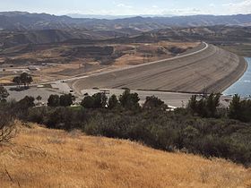
Castaic Dam
| Castaic Dam | |
|---|---|

View from the northeast.
|
|
| Location | Castaic, United States |
| Coordinates | 34°31′09″N 118°36′25″W / 34.51917°N 118.60694°WCoordinates: 34°31′09″N 118°36′25″W / 34.51917°N 118.60694°W |
| Opening date | 1973 |
| Dam and spillways | |
| Type of dam | Earthfill |
| Impounds | Castaic Creek |
| Height | 340 ft (100 m) |
| Length | 5,200 ft (1,600 m) |
| Dam volume | 44,000,000 cu yd (34,000,000 m3) |
| Spillway type | Uncontrolled overflow |
| Reservoir | |
| Creates | Castaic Lake |
| Total capacity | 325,000 acre·ft (401,000,000 m3) |
| Catchment area | 153.7 sq mi (398 km2) |
| Surface area | 2,235 acres (904 ha) |
| Power station | |
| Installed capacity | 11 MW |
Castaic Dam is an embankment dam in northern Los Angeles County, California, near the city of Castaic. Although located on Castaic Creek, a major tributary of the Santa Clara River, Castaic Creek provides little of its water. The lake is the terminus of the West Branch of the California Aqueduct, part of the State Water Project. The dam was built by the California Department of Water Resources and construction was completed in 1973. The lake has a capacity of 325,000 acre feet (401,000,000 m3) and stores drinking water for the western portion of the Greater Los Angeles Area.
Castaic is an earth-fill dam with its surfaces covered with boulders and cobble-sized rocks to prevent erosion. The dam is 340 feet (100 m) high above the streambed, 425 feet (130 m) above the foundations, and 5,200 feet (1,600 m) long, containing 44 million cubic yards (34,000,000 m3) of material. The maximum thickness of the base is 2,350 feet (720 m). Flood waters are released through an ungated, concrete overflow spillway on the west side of the dam, emptying into a stilling basin called Castaic Lagoon (colloquially referred to as the "Lower Lake", while the larger Castaic Lake is called "Upper Lake"). The total storage capacity of Castaic Lake is 325,000 acre·ft (401,000,000 m3), of which 31,000 acre feet (38,000,000 m3) is considered active capacity and 294,000 acre feet (363,000,000 m3) are considered inactive. The inactive capacity is only used during periods of extended drought or interrupted water delivery, most recently in 2014. At maximum water elevation of 1,509 ft (460 m) AMSL, the lake covers 2,235 acres (904 ha), with 29 miles (47 km) of shoreline. The much smaller Castaic Lagoon can hold 5,560 acre·ft (6,860,000 m3) and covers 200 acres (81 ha).
...
Wikipedia
