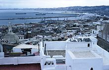
Casbah of Algiers
| Kasbah of Algiers | |
|---|---|
| Name as inscribed on the World Heritage List | |
 |
|
| Type | Cultural |
| Criteria | ii, v |
| Reference | 565 |
| UNESCO region | Arab States |
| Coordinates | 36°47′0″N 3°3′37″E / 36.78333°N 3.06028°ECoordinates: 36°47′0″N 3°3′37″E / 36.78333°N 3.06028°E |
| Inscription history | |
| Inscription | 1992 (16th Session) |
The Casbah (Arabic: , qaṣba, meaning citadel (fortress)) is specifically the citadel of Algiers in Algeria and the traditional quarter clustered around it. More generally, a kasbah is the walled citadel of many North African cities and towns. The name made its way into English from French in the late 19th century (the Oxford English Dictionary states 1895), and often is spelled "kasbah," but also "casbah."
The Casbah of Algiers is founded on the ruins of old Icosium. It was a mid-sized city which, built on a hill, goes down towards the sea, divided in two: the High city and the Low city. One finds there masonries and mosques of the 17th century; Ketchaoua mosque (built in 1794 by the Dey Baba Hassan) flanked of two minarets, mosque el Djedid (1660, at the time of Turkish regency) with its large finished ovoid cupola points some and its four coupolettes, mosque El Kébir (oldest of the mosques, it was built by Almoravid ruler Yusuf ibn Tashfin and rebuilt later in 1794), mosque Ali Betchnin (Raïs, 1623), Dar Aziza, palate of Jénina. The Palace was built in 1791 to house the Pasha, who lived there for eight years.
In 1839, the French governor moved into the palace. In 1860, Napoleon III and Eugénie de Montijo visited. The Casbah played a central role during the Algerian struggle for independence (1954–1962). The Casbah was the epicenter of the insurgency planning of the National Liberation Front (FLN) and gave them a safe haven to plan and execute attacks against French citizens and law enforcement agents in Algeria at the time. In order to counter their efforts, the French had to focus specifically on the Casbah.
...
Wikipedia

