Casa de Oro-Mount Helix, California
| Casa de Oro-Mount Helix | |
|---|---|
| Census designated place | |
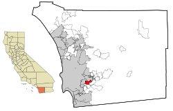
 Location in San Diego County and the state of California |
|
| Location in the United States | |
| Coordinates: 32°45′48″N 116°58′39″W / 32.76333°N 116.97750°WCoordinates: 32°45′48″N 116°58′39″W / 32.76333°N 116.97750°W | |
| Country |
|
| State |
|
| County | San Diego |
| Area | |
| • Total | 6.853 sq mi (17.749 km2) |
| • Land | 6.853 sq mi (17.749 km2) |
| • Water | 0 sq mi (0 km2) 0% |
| Population (April 1, 2010) | |
| • Total | 18,762 |
| • Density | 2,700/sq mi (1,100/km2) |
| Time zone | Pacific (UTC-8) |
| • Summer (DST) | PDT (UTC-7) |
| ZIP codes | 92041, 92077 |
| Area code | 619 |
| FIPS code | 06-11691 |
| GNIS feature ID | 2407979 |
Casa de Oro-Mount Helix is a census-designated place (CDP) in San Diego County, California. The CDP encompasses several neighborhoods in unincorporated parts of the county near the cities of El Cajon and La Mesa as well as part of the unincorporated community of Spring Valley. The CDP gets its name from the neighborhood of Casa de Oro, which straddles the line between Spring Valley and unincorporated El Cajon, and Mount Helix, a prominent hill in La Mesa. The population was 18,762 at the 2010 census, down from 18,874 at the 2000 census.
Casa de Oro-Mount Helix is located at 32°45′48″N 116°58′39″W / 32.76333°N 116.97750°W (32.763359, -116.977474).
According to the United States Census Bureau, the CDP has a total area of 6.9 square miles (18 km2), all land.
The 2010 United States Census reported that Casa de Oro-Mount Helix had a population of 18,762. The population density was 2,737.8 people per square mile (1,057.1/km²). The racial makeup of Casa de Oro-Mount Helix was 14,881 (79.3%) White, 1,108 (5.9%) African American, 89 (0.5%) Native American, 593 (3.2%) Asian, 96 (0.5%) Pacific Islander, 996 (5.3%) from other races, and 999 (5.3%) from two or more races. Hispanic or Latino of any race were 3,235 persons (17.2%).
...
Wikipedia

