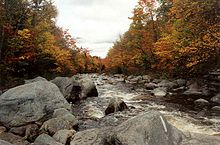
Carrabassett River
| Carrabassett River | |
|---|---|

South Branch Carrabassett River at the AT crossing
|
|
| Country | United States |
| Basin features | |
| Main source |
Maine 2,720 feet (830 m) |
| River mouth |
Kennebec River 245 feet (75 m) 44°50′56″N 69°52′37″W / 44.849°N 69.877°WCoordinates: 44°50′56″N 69°52′37″W / 44.849°N 69.877°W |
| Physical characteristics | |
| Length | 33.8 miles (54.4 km) |
The Carrabassett River, a tributary of the Kennebec River, is located in Franklin County and Somerset County, Maine, in the United States. It rises near Sugarloaf Mountain, east of Rangeley Lake, and runs for 33.8 miles (54.4 km), flowing southeast past Kingfield and joining the Kennebec River in the town of Anson.
The South Branch Carrabassett River, 11.9 miles (19.2 km) long, begins in Franklin County at Caribou Pond, fed by small brooks and wetlands between Spaulding Mountain to the east and Mount Redington to the west. From the outflow of Caribou Pond (45°00′32″N 70°21′23″W / 45.0090°N 70.3565°W), the South Branch flows north through Caribou Valley, between Crocker Mountain and Sugarloaf Mountain. The Appalachian Trail crosses the South Branch in Caribou Valley. Near the village of Bigelow, the river turns east, collecting brooks draining Sugarloaf Mountain, known for Sugarloaf ski resort. At Bigelow, the river is bridged by State Route 16 & 27. Route 16 and the narrow gauge Sandy River and Rangeley Lakes Railroad follow the river from Bigelow downstream to Kingfield.
...
Wikipedia
