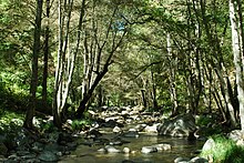
Carmel River
| Carmel River | |
|---|---|
 |
|
| Other name(s) | Rio del Carmelo, Carmelo River, Nuestra Senora del Monte Carmelo |
| Country | United States |
| Basin features | |
| Main source |
Santa Lucia Mountains 36°19′05″N 121°38′44″W / 36.318018°N 121.645501°W |
| River mouth |
Pacific Ocean Sea level 36°32′10″N 121°55′41″W / 36.536072°N 121.928010°WCoordinates: 36°32′10″N 121°55′41″W / 36.536072°N 121.928010°W |
| Basin size | 660 km2 (250 sq mi) |
| Physical characteristics | |
| Length | 36 mi (58 km) |
The Carmel River is a 36 mi (58 km) river on the Central Coast of California in Monterey County that originates in the Ventana Wilderness Area of the Santa Lucia Mountains. The river flows northwest through the Carmel Valley with its mouth at the Pacific Ocean south of Carmel-by-the-Sea, at Carmel Bay. It is often considered the northern boundary of Big Sur. The Carmel River drains a watershed of about 255 square miles (660 km²).
The river was visited on January 3, 1603 by Spanish maritime explorer Sebastián Vizcaíno, whose written account greatly exaggerated its proportions, confusing later explorers. Vizcaino named it Rio del Carmelo, likely because his voyage was accompanied by three Carmelite friars. In 1771 Fathers Junípero Serra and Juan Crespí moved Mission San Carlos Borromeo de Carmelo from Monterey to its present site by the Carmel River.
In his 1945 novel Cannery Row John Steinbeck wrote "The Carmel is a lovely little river. It isn't very long but in its course it has everything a river should have."
The river flows through various habitats beyond its bankside riparian zone: starting in mixed evergreen forests, then down through montane chaparral and woodlands to remnant coastal sage and chaparral and coastal prairie, concluding through minor coastal sand dunes at its Pacific mouth.
...
Wikipedia
