Carisbrook, Victoria
|
Carisbrook Victoria |
|
|---|---|

St Paul's Anglican church
|
|
| Coordinates | 37°02′53″S 143°49′01″E / 37.04806°S 143.81694°ECoordinates: 37°02′53″S 143°49′01″E / 37.04806°S 143.81694°E |
| Population | 713 (2006 census) |
| Established | late 1840s - early 1850s |
| Postcode(s) | 3464 |
| Location |
|
| LGA(s) | Shire of Central Goldfields |
| State electorate(s) | Ripon |
| Federal Division(s) | Bendigo |
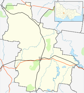
Carisbrook is a town in Victoria, Australia, located on the Pyrenees Highway, 7 kilometres (4.3 mi) east of the regional and local government centre of Maryborough, in the Shire of Central Goldfields. At the 2006 census, Carisbrook had a population of 713. Carisbrook is closely linked with Maryborough historically, socially and economically.
Carisbrook situated on the Pyrenees Highway between Maryborough and Castlemaine, with coach services to both of these towns.
The Moolort railway line is a partially closed railway line also connecting Maryborough to Castlemaine, via Carisbrook station and Moolort.
The Carisbrook Mercury is a weekly newspaper distributed locally, based in Carisbrook Town Hall. The Maryborough Advertiser, distributed in the Central Goldfields region, and the regional radio station, Goldfields FM 99.1, are based in Maryborough.
The local Australian Rules Football team is the Carisbrook Redbacks. They play in the Maryborough Castlemaine District Football League. The Maryborough Harness Racing Club conducts regular meetings at its racetrack, which is in fact located near Carisbrook. There is also a lawn bowls club, a gun club and a leisure centre.
...
Wikipedia

