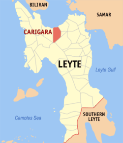
Carigara, Leyte
| Carigara | |
|---|---|
| Municipality | |
 Map of Leyte with Carigara highlighted |
|
| Location within the Philippines | |
| Coordinates: 11°18′N 124°41′E / 11.300°N 124.683°ECoordinates: 11°18′N 124°41′E / 11.300°N 124.683°E | |
| Country | Philippines |
| Region | Eastern Visayas (Region VIII) |
| Province | Leyte |
| District | 2nd district of Leyte |
| Barangays | 49 |
| Government | |
| • Mayor | Eduardo Ong |
| Area | |
| • Total | 117.86 km2 (45.51 sq mi) |
| Population (2015 census) | |
| • Total | 51,345 |
| • Density | 440/km2 (1,100/sq mi) |
| Time zone | PST (UTC+8) |
| ZIP code | 6529 |
| IDD : area code | +63 (0)53 |
| Income class | 2nd municipal income class |
| 083715000 | |
| Electorate | 32,501 voters as of 2016 |
| Website | www |
Carigara is a 2nd class municipality in the province of Leyte, Philippines. According to the 2015 census, it has a population of 51,345 people.
It is a town in northern Leyte located right on the shore of Carigara Bay, and surrounded by wide rice fields fanning out towards the mountains in the distance.
Carigara is politically subdivided into 49 barangays.
Carigara was originally called Kangara, meaning "that of Gara" or simply "Gara's". Gara was said to have come from Borneo, one of the unnamed companions of the ten datus who landed in Panay and purchased that island from the Ati (or Aeta) chief Marikudo. Later, for phonetic convenience, Kangara became Kalgara and when the Spaniards came, they called the place Carigara; hence its present name.
Carigara has a history unique from its neighboring towns. It is the first town established in Eastern Visayas. Its town fiesta which is celebrated every 16 July, commemorates the day of the first coming of the Spaniards dated July 16, 1569. The fiesta that is celebrated almost the entire month of July was dubbed as the Fiesta of the Holy Cross.
...
Wikipedia

