Carcassonne Airport
|
Carcassonne Airport Aéroport de Carcassonne |
|||||||||||||||
|---|---|---|---|---|---|---|---|---|---|---|---|---|---|---|---|
 |
|||||||||||||||
| Summary | |||||||||||||||
| Airport type | Public | ||||||||||||||
| Operator | Transdev | ||||||||||||||
| Serves | Carcassonne, France | ||||||||||||||
| Elevation AMSL | 434 ft / 132 m | ||||||||||||||
| Coordinates | 43°12′57″N 002°18′31″E / 43.21583°N 2.30861°ECoordinates: 43°12′57″N 002°18′31″E / 43.21583°N 2.30861°E | ||||||||||||||
| Website | Carcassonne airport | ||||||||||||||
| Maps | |||||||||||||||
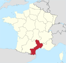
 Location of Languedoc-Roussillon region in France |
|||||||||||||||
| Location of airport in Languedoc-Roussillon region | |||||||||||||||
| Runways | |||||||||||||||
|
|||||||||||||||
| Statistics (2014) | |||||||||||||||
|
|||||||||||||||
| Passengers | 413,724 |
|---|---|
| Passenger Change 13-14 |
|
Carcassonne Airport (French: Aéroport de Carcassonne) (IATA: CCF, ICAO: LFMK) is an airport serving Carcassonne and the south of Languedoc. The airport is located on the western edge of the city, 3 km (2 nautical miles) from the city center, in the Aude department of the Languedoc-Roussillon region in France. It is also known as Salvaza Airport,Carcassonne Salvaza Airport or Carcassonne Airport in Pays Cathare (Aéroport de Carcassonne en Pays Cathare). The airport handles commercial national and international flights as well as private, non-regular air traffic.
In the late 1990s the airport started taking budget flights to and from European airports and in 2006 had regular flight connections with Dublin, Stansted, Liverpool, East Midlands and Charleroi. In 2011, the airport served 368,000 passengers.
The airport sits at an elevation of 434 feet (132 m) above mean sea level. It has one paved runway designated which measures 2,050 by 45 metres (6,726 ft × 148 ft). It also has a parallel unpaved runway with a grass surface measuring 800 by 30 metres (2,625 ft × 98 ft). It can cater for aircraft operating under VFR.
...
Wikipedia

