Carauari
| Carauari | |||
|---|---|---|---|
| Municipality | |||
|
|||
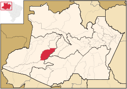
 Location of the municipality inside Amazonas |
|||
| Location in Brazil | |||
| Coordinates: 4°52′58″S 66°53′45″W / 4.88278°S 66.89583°WCoordinates: 4°52′58″S 66°53′45″W / 4.88278°S 66.89583°W | |||
| Country |
|
||
| Region | North | ||
| State |
|
||
| Time zone | BRT (UTC−4) | ||
| • Summer (DST) | DST no longer used (UTC−4) | ||
Carauari is a municipality located in the Brazilian state of Amazonas. Its population was 25,918 (2005) and its area is 25,767 km².
The city is served by Carauari Airport.
The town is in the Juruá-Purus moist forests ecoregion. The municipality contains about 5% of the Tefé National Forest, created in 1989. The municipality contains 251,577 hectares (621,660 acres) Médio Juruá Extractive Reserve, created in 1997, on the left bank of the meandering Juruá River. It also contains the 632,949 hectares (1,564,050 acres) Uacari Sustainable Development Reserve, created in 2005.
...
Wikipedia


