Capon Bridge, West Virginia
| Town of Capon Bridge, West Virginia | |
|---|---|
| Town | |

Northwestern Pike (US 50) in Capon Bridge
|
|
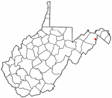
 Location of Capon Bridge in West Virginia |
|
| Coordinates: 39°17′54″N 78°26′12″W / 39.29833°N 78.43667°WCoordinates: 39°17′54″N 78°26′12″W / 39.29833°N 78.43667°W | |
| Country | United States |
| State | West Virginia |
| County | Hampshire |
| Government | |
| • Mayor | Steve Sirbaugh |
| Area | |
| • Total | 0.70 sq mi (1.81 km2) |
| • Land | 0.67 sq mi (1.74 km2) |
| • Water | 0.03 sq mi (0.08 km2) |
| Elevation | 791 ft (241 m) |
| Population (2010) | |
| • Total | 355 |
| • Estimate (2012) | 354 |
| • Density | 529.9/sq mi (204.6/km2) |
| Time zone | EST (UTC-5) |
| • Summer (DST) | EDT (UTC-4) |
| ZIP code | 26711 |
| Area code(s) | 304 |
| FIPS code | 54-13108 |
| GNIS feature ID | 1537027 |
Capon Bridge is a town located in eastern Hampshire County, West Virginia, USA, along the Northwestern Turnpike (U.S. Route 50), approximately twenty miles west of Winchester, Virginia. The population was 355 at the 2010 census, 200 of which live within the town limits. Originally known as Glencoe, Capon Bridge was incorporated in 1902 by the Hampshire County Circuit Court. It is named because of the construction of the bridge over the Cacapon River at that place, the name of the river being derived from the Shawnee Cape-cape-de-hon, meaning "river of medicine water".
Capon Bridge is located at 39°17′54″N 78°26′12″W / 39.29833°N 78.43667°W (39.298405, -78.436797).
According to the United States Census Bureau, the town has a total area of 0.70 square miles (1.81 km2), of which, 0.67 square miles (1.74 km2) is land and 0.03 square miles (0.08 km2) is water. The local restaurant El Puente located in Capon Bridge means The Bridge. (Random Trivia)
As of the census of 2010, there were 355 people, 156 households, and 96 families residing in the town. The population density was 529.9 inhabitants per square mile (204.6/km2). There were 180 housing units at an average density of 268.7 per square mile (103.7/km2). The racial makeup of the town was 96.9% White, 1.7% African American, 0.6% from other races, and 0.8% from two or more races. Hispanic or Latino of any race were 3.1% of the population.
...
Wikipedia
