Capiz province
| Capiz | |||
|---|---|---|---|
| Province | |||
| Province of Capiz | |||
|
|||
| Anthem: O, Capiz | |||
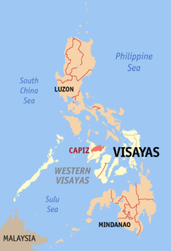
 Location in the Philippines |
|||
| Coordinates: 11°23′N 122°38′E / 11.38°N 122.63°ECoordinates: 11°23′N 122°38′E / 11.38°N 122.63°E | |||
| Country | Philippines | ||
| Region | Western Visayas (Region VI) | ||
| Discovered | 1566 | ||
| Encomienda | 1569 | ||
| Politico-Military Province | 1716 | ||
| Founded | April 15, 1901 | ||
| Capital | Roxas | ||
| Government | |||
| • Type | Sangguniang Panlalawigan | ||
| • Governor | Antonio del Rosario (LP) | ||
| • Vice Governor | Esteban Contreras (LP) | ||
| Area | |||
| • Total | 2,594.64 km2 (1,001.80 sq mi) | ||
| Area rank | 52nd out of 81 | ||
| Highest elevation (Mount Nangtud) | 2,205 m (7,234 ft) | ||
| Population (2015 census) | |||
| • Total | 761,384 | ||
| • Rank | 38th out of 81 | ||
| • Density | 290/km2 (760/sq mi) | ||
| • Density rank | 25th out of 81 | ||
| Time zone | PST (UTC+8) | ||
| ZIP Code | 5800–5816 | ||
| IDD : area code | +63 (0)36 | ||
| ISO 3166 code | PH | ||
| Spoken languages | |||
| Website | capiz |
||
Capiz is a province located in the region of Western Visayas in the central section of the Philippines. Its capital is the city of Roxas and is located at the northeastern portion of Panay Island, bordering Aklan and Antique to the west, and Iloilo to the south. Capiz faces the Sibuyan Sea to the north.
Capiz is known for the Placuna placenta oyster shell that has the same name locally and is used for decoration and making lampshades, trays, window and doors. Likewise, the province is known as the "Seafood Capital of the Philippines" and was among the top 15 most frequently visited places in the Philippines. Capiz is the site of the famous coral-stone Santa Monica Church in the town of Pan-ay, home to the largest Catholic Church bell in Asia. The bell was made from 70 sacks of gold and silver coins donated by the townsfolk. Measuring seven feet in diameter, five feet in height and weighing 10,400 kilograms or just over 10 metric tons, the Pan-ay bell is popular among tourists visiting Capiz.
The account of early Spanish explorers about Capiz and its people was traced back in the year 1566 when the Spaniards set foot in the mouth of Banica river. Early settlements were seen in the town of Pan-ay which the town originally called "Bamban" which was changed by the early Spaniards to "Panay", a word which means "mouth of the river." This is also the location of a fortress built by Juan de la Isla in late 1570. The Paseo de Evangelizacion 1566 can be found in the town plaza and was erected through the efforts of Rev. Msgr. Benjamin F. Advincula.
When the Spaniards led by Miguel López de Legazpi came to Panay from Cebu in 1569, they found people with tattoos, and so they called the island Isla de los Pintados. How the island itself came to be called Panay is uncertain. The Aeta called it Aninipay, after a plant that abounded in the island. Legend has it that López de Legazpi and his men, in search of food, exclaimed upon the island, pan hay en esta isla!. They established their first settlement on the island at the mouth of the Banica River and called it Pan-ay. This was the second Spanish settlement in the Philippines, following San Miguel, Cebu. Unknown to many, Calle Revolución in Panay town is the second oldest street in the Philippines after Calle Colon in Cebu City, Central Visayas.
...
Wikipedia


