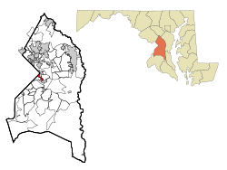
Capitol Heights, Maryland
| Capitol Heights, Maryland | |
|---|---|
| Town | |
 Location of Capitol Heights, Maryland |
|
| Coordinates: 38°52′55″N 76°54′52″W / 38.88194°N 76.91444°WCoordinates: 38°52′55″N 76°54′52″W / 38.88194°N 76.91444°W | |
| Country | |
| State |
|
| County | |
| Area | |
| • Total | 0.80 sq mi (2.07 km2) |
| • Land | 0.80 sq mi (2.07 km2) |
| • Water | 0 sq mi (0 km2) |
| Elevation | 121 ft (37 m) |
| Population (2010) | |
| • Total | 4,337 |
| • Estimate (2012) | 4,428 |
| • Density | 5,421.3/sq mi (2,093.2/km2) |
| Time zone | Eastern (EST) (UTC-5) |
| • Summer (DST) | EDT (UTC-4) |
| ZIP codes | 20700-20799 |
| Area code(s) | 301 and 240 |
| FIPS code | 24-13000 |
| GNIS feature ID | 0597177 |
Capitol Heights is a town in Prince George's County, Maryland, United States. The population was 4,337 at the 2010 census. Development around the Capitol Heights Metro station has medical facilities and eateries to support the community. The Washington Redskins football stadium is just to the east of Capitol Heights, near the Capital Beltway (I-95/495) and Kingdom Square (formerly Hampton Mall) shopping center which features a hotel and eateries.
The town borders Washington, D.C., and has a ZIP code of 20743.
Capitol Heights is located at 38°52′55″N 76°54′52″W / 38.88194°N 76.91444°W (38.881862, -76.914474).
According to the United States Census Bureau, the town has a total area of 0.80 square miles (2.07 km2), all of it land.
As of the census of 2010, there were 4,337 people, 1,482 households, and 1,040 families residing in the town. The population density was 5,421.3 inhabitants per square mile (2,093.2/km2). There were 1,622 housing units at an average density of 2,027.5 per square mile (782.8/km2). The racial makeup of the town was 3.3% White, 91.3% African American, 0.3% Native American, 0.1% Asian, 3.1% from other races, and 1.9% from two or more races. Hispanic or Latino of any race were 5.4% of the population.
...
Wikipedia
