Capital Reef National Park
| Capitol Reef National Park | |
|---|---|
|
IUCN category II (national park)
|
|

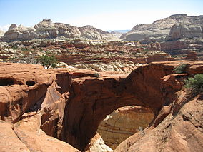
Cassidy Arch
|
|
| Location | Wayne, Garfield, Sevier, and Emery counties, Utah, USA |
| Nearest city | Torrey |
| Coordinates | 38°12′N 111°10′W / 38.200°N 111.167°WCoordinates: 38°12′N 111°10′W / 38.200°N 111.167°W |
| Area | 241,904 acres (978.95 km2) 670 acres (270 ha) private |
| Established | December 18, 1971 |
| Visitors | 1,064,904 (in 2016) |
| Governing body | National Park Service |
| Website | Capitol Reef National Park |
Capitol Reef National Park is a United States National Park, in south-central Utah. The park is approximately 60 miles (97 km) long on its north–south axis but an average of just 6 miles (9.7 km) wide. The park was established in 1971 to preserve 241,904 acres (377.98 sq mi; 97,895.08 ha; 978.95 km2) of desert landscape and is open all year with May through September being the highest visitation months.
Located partially in Wayne County, Utah, the area was originally named "Wayne Wonderland" in the 1920s by local boosters Ephraim P. Pectol and Joseph S. Hickman. Capitol Reef National Park was initially designated a National Monument on August 2, 1937 by President Franklin D. Roosevelt in order to protect the area's colorful canyons, ridges, buttes, and monoliths; however, it was not until 1950 that the area officially opened to the public. Easy road access only came in 1962 with the construction of State Route 24 through the Fremont River Canyon.
The majority of the nearly 100 mi (160 km) long up-thrust formation called the Waterpocket Fold—a rocky spine extending from Thousand Lake Mountain to Lake Powell—is preserved within the park. Capitol Reef is the name of an especially rugged and spectacular segment of the Waterpocket Fold by the Fremont River. The park was named for a line of cliffs of white Navajo Sandstone with dome formations—similar to the white domes often placed on capitol buildings—that run from the Fremont River to Pleasant Creek on the Waterpocket Fold. The local word reef refers to any rocky barrier to land travel, just as ocean reefs are barriers to sea travel.
Capitol Reef encompasses the Waterpocket Fold, a warp in the earth's crust that is 65 million years old. It is the largest exposed monocline in North America. In this fold, newer and older layers of earth folded over each other in an S-shape. This warp, probably caused by the same colliding continental plates that created the Rocky Mountains, has weathered and eroded over millennia to expose layers of rock and fossils. The park is filled with brilliantly colored sandstone cliffs, gleaming white domes, and contrasting layers of stone and earth.
...
Wikipedia

