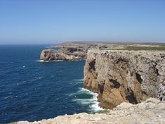
Cape St. Vincent
| Cape St. Vincent | |
|---|---|
| Cabo de São Vicente | |

North shore of Cape St. Vincent as seen from the lighthouse
|
|
| Highest point | |
| Peak | Cabo de São Vicente (Southwest Alentejo and Vicentine Coast Natural Park) |
| Coordinates | 37°1′30″N 8°59′40″W / 37.02500°N 8.99444°WCoordinates: 37°1′30″N 8°59′40″W / 37.02500°N 8.99444°W |
| Naming | |
| Etymology | Vincent of Saragossa |
| Geography | |
| Country |
|
| Region | Algarve |
| Subregion | Algarve |
| District | Faro |
Cape St. Vincent (Portuguese: Cabo de São Vicente, Portuguese pronunciation: [ˈkabu dɨ sɐ̃w̃ viˈsẽtɨ]), next to the Sagres Point, on the so-called Costa Vicentina (Vincentine Coast), is a headland in the municipality of Vila do Bispo, in the Algarve, southern Portugal.
Cape St. Vincent was already sacred ground in Neolithic times, as standing menhirs in the neighborhood attest. The ancient Greeks called it Ophiussa (Land of Serpents), inhabited by the Oestriminis and dedicated here a temple to Heracles. The Romans called it Promontorium Sacrum (or Holy Promontory). They considered it a magical place where the sunset was much larger than anywhere else. They believed the sun sank here hissing into the ocean, marking the edge of their world.
According to legend, the name of this cape is linked to the story of a martyred fourth-century Iberian deacon St. Vincent whose body was brought ashore here. A shrine was erected over his grave; according to the Arab geographer Al-Idrisi, it was always guarded by ravens and is therefore named by him كنيسة الغراب (Kanīsah al-Ghurāb, meaning "Church of the Raven"). King Afonso Henriques (1139–1185) had the body of the saint exhumed in 1173 and brought it by ship to Lisbon, still accompanied by the ravens. This transfer of the relics is depicted on the coat of arms of Lisbon.
...
Wikipedia

