Capas, Tarlac
| Capas | ||
|---|---|---|
| Municipality | ||

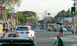
Intersection of MacArthur Highway as seen near Caltex in Capas
|
||
|
||
| Nickname(s): Capas-Capas, Paspas-Capas | ||
| Motto: Paspas Capas | ||
 Map of Tarlac showing the location of Capas |
||
| Location within the Philippines | ||
| Coordinates: 15°19′39″N 120°35′27″E / 15.3275°N 120.5908°ECoordinates: 15°19′39″N 120°35′27″E / 15.3275°N 120.5908°E | ||
| Country | Philippines | |
| Region | Central Luzon (Region III) | |
| Province | Tarlac | |
| District | 3rd District | |
| Founded | 1710 | |
| Barangays | 20 | |
| Government | ||
| • Mayor | Reynaldo Catacutan | |
| • Vice Mayor | Roseller Rodriguez | |
| Area | ||
| • Total | 376.39 km2 (145.32 sq mi) | |
| Elevation | 46 m (151 ft) | |
| Population (2015 census) | ||
| • Total | 140,202 | |
| • Density | 370/km2 (960/sq mi) | |
| Time zone | PST (UTC+8) | |
| ZIP code | 2315 | |
| IDD : area code | +63 (0)45 | |
| Income class | 1st class | |
| Website | www |
|
Capas (Kapampangan: Balen ning Capas; Ilocano: Ili ti Capas; Filipino: Bayan ng Capas) is a first class highly urbanized municipality in the province of Tarlac, Philippines, and one of the richest towns in the province. The town also consists of numerous subdivisions and exclusive villages. According to the 2015 census, it has a population of 140,202 people.
Capas is being dubbed as the “Tourism Capital of Tarlac”. Apart from being known as the final site of infamous Bataan Death March, it is also known for Mount Pinatubo treks, where thousands of mountaineers and visitors go. The town has some industrial factories like the PilMiCo.
Capas is a part of the Third Municipal district of Tarlac with Noel L. Villanueva as the present Third District Representative of Tarlac.
Capas has relatively high ground, hilly places near the mountain range are at an approximate 46 meters. It is bordered by San Jose on the north, Tarlac City on the north-east, Concepcion on the east, Botolan, Zambales, on the west and south-west and Bamban on the rest of the southern parts. The west side of the town is mountainous while the east side is a plain. The town is also known as "The Gateway to Pinatubo Volcano." The town also consists of Hot springs and several freshwater lakes like the Tambo Lake.
Many of the streams in the province contain small bits of petrified wood, fish, fresh water crabs and other animals. Namria and Dingding creek merge as the two major tributaries to Lucong river in Concepcion. Most of Tarlac's waterways that originate from Mount Pinatubo pass through Capas, including the Bulsa Moriones River and Sta. Lucia River that form Tarlac River.
...
Wikipedia


