Canton, Georgia
| Canton, Georgia | |
|---|---|
| City | |

Canton Town Square
|
|
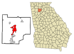
 Location in Cherokee County in the state of Georgia |
|
| Location of Canton in Metro Atlanta | |
| Coordinates: 34°13′38″N 84°29′41″W / 34.22722°N 84.49472°WCoordinates: 34°13′38″N 84°29′41″W / 34.22722°N 84.49472°W | |
| Country | United States |
| State | Georgia |
| County | Cherokee |
| Government | |
| • Mayor | Gene Hobgood (R) |
| • City Council | Bob Rush E.H. Huffman Bill Bryan Jack Goodwin Glen Cummins John Beresford |
| Area | |
| • Total | 18.7 sq mi (48.5 km2) |
| • Land | 18.6 sq mi (48.2 km2) |
| • Water | 0.2 sq mi (0.4 km2) |
| Elevation | 968 ft (295 m) |
| Population (2010) | |
| • Total | 22,958 |
| • Density | 1,235/sq mi (476.8/km2) |
| Time zone | EST (UTC-5) |
| • Summer (DST) | EDT (UTC-4) |
| ZIP codes | 30114, 30115, 30169 |
| Area code(s) | 770/678/470 |
| FIPS code | 13-12988 |
| GNIS feature ID | 0331320 |
| Website | www |
Canton is a city in and the county seat of Cherokee County,Georgia, United States. As of the 2010 census, the city had a population of 22,958, up from 7,709 at the 2000 census.
Canton is located near the center of Cherokee County at 34°13′38″N 84°29′41″W / 34.22722°N 84.49472°W (34.227307, −84.494727). The city lies just north of Holly Springs and south of Ball Ground. Interstate 575 passes through the eastern side of the city, with access from exits 14 through 20. Canton is 40 miles (64 km) north of downtown Atlanta via I-575 and I-75.
According to the United States Census Bureau, the city has a total area of 18.7 square miles (48.5 km2), of which 18.6 square miles (48.2 km2) is land and 0.15 square miles (0.4 km2), or 0.76%, is water. The Etowah River, a tributary of the Coosa River, flows from east to west through the center of the city.
As of the 2010 census, there were 22,958 people, 8,204 households, and 5,606 families residing in the city. The population density was 1,234.3 people per square mile (476.8/km²). There were 9,341 housing units at an average density of 502.2 per square mile (194.0/km²).
There were 8,204 households, out of which 42.4% had children under the age of 18 living with them, 48.6% were headed by married couples living together, 14.5% had a female householder with no husband present, and 31.7% were non-families. 25.3% of all households were made up of individuals, and 7.8% were someone living alone who was 65 years of age or older. The average household size was 2.77, and the average family size was 3.30.
...
Wikipedia


