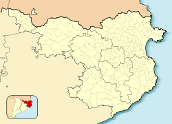
Cantallops
| Cantallops | |||
|---|---|---|---|
| Municipality | |||

Entrance to the village
|
|||
|
|||
| Location in Catalonia | |||
| Coordinates: 42°25′28″N 2°55′34″E / 42.42444°N 2.92611°ECoordinates: 42°25′28″N 2°55′34″E / 42.42444°N 2.92611°E | |||
| Country |
|
||
| Community |
|
||
| Province | Girona | ||
| Comarca | Alt Empordà | ||
| Government | |||
| • Mayor | Joan Sabartés Olivet (2015) | ||
| Area | |||
| • Total | 19.6 km2 (7.6 sq mi) | ||
| Elevation | 200 m (700 ft) | ||
| Population (2014) | |||
| • Total | 324 | ||
| • Density | 17/km2 (43/sq mi) | ||
| Demonym(s) | Cantallobenc, cantallobenca | ||
| Website | www |
||
Cantallops is a municipality in the comarca of the Alt Empordà in Girona, Catalonia, Spain. It is situated below the Albera Range, and is linked to La Jonquera by the GI-601 road.
...
Wikipedia


