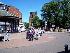
Cannock
| Cannock | |
|---|---|
 Market Place |
|
| Cannock shown within Staffordshire | |
| Area | 9.24 km2 (3.57 sq mi) |
| Population | 29,018 (2011 Census) |
| • Density | 3,140/km2 (8,100/sq mi) |
| OS grid reference | SJ980101 |
| District | |
| Shire county | |
| Region | |
| Country | England |
| Sovereign state | United Kingdom |
| Post town | CANNOCK |
| Postcode district | WS11 |
| Dialling code | 01543 |
| Police | Staffordshire |
| Fire | Staffordshire |
| Ambulance | West Midlands |
| EU Parliament | West Midlands |
| UK Parliament | |
Cannock (/ˈkænək/), as of the 2011 census, has a population of 29,018, and is the most populous of the three towns in the district of Cannock Chase in the central southern part of the county of Staffordshire in the West Midlands region of England.
Cannock lies to the north of the West Midlands conurbation on the M6, A34 and A5 roads, and to the south of Cannock Chase, an Area of Outstanding Natural Beauty (AONB). Cannock is served by a railway station on the Chase Line. The town comprises four district council electoral wards and the Cannock South ward includes the civil parish of Bridgtown, but the rest of Cannock is unparished.
Cannock forms part of the Cannock Built-up Area (population 86,121 in the 2011 census) which also includes Cheslyn Hay, Great Wyrley, Hednesford, Huntington, Heath Hayes and Wimblebury.
...
Wikipedia

