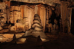
Cango Caves

Speleothems in the caves
|
|
| Location | foothills of the Swartberg, near Oudtshoorn |
|---|---|
| Region | South Africa |
| Coordinates | 33°23′34″S 22°12′53″E / 33.39278°S 22.21472°ECoordinates: 33°23′34″S 22°12′53″E / 33.39278°S 22.21472°E |
| History | |
| Material | Precambrian limestone |
| Site notes | |
| Excavation dates | 1930 |
| Archaeologists | A.J.H. Goodwin |
The Cango Caves are located in Precambrian limestones at the foothills of the Swartberg range near the town of Oudtshoorn, in the Western Cape Province of South Africa. The principal cave is one of the country's finest, best known, and most popular tourist caves and attracts many visitors from overseas. Although the extensive system of tunnels and chambers go on for over 4 km (2.5 mi), only about a quarter of this is open to visitors, who may proceed into the cave only in groups supervised by a guide.
Cave paintings and artifacts indicate that the caves were in use throughout prehistory over a long period during the Middle and Later Stone Ages .
The caves were rediscovered in modern times in 1780 by a local farmer named Jacobus Van Zyl. The chamber he first was lowered down into was found to be as long as a football field, and is named Van Zyl Hall in his honor. Further exploration was done and a second chamber discovered in 1792. The caves soon became a popular place to visit.
A.J.H. Goodwin, an archaeologist at the University of Cape Town, carried out a test excavation in the Cango Caves in 1930 which found stone artefacts and other cultural material.
The Cango Caves Ordinance of 1971 gave certain legal powers over the caves to what was then the Administrator of the Cape; legally, these same powers now devolve to the local government members of the executive. However, day-to-day management of the caves is the responsibility of the municipality of Oudtshoorn.
Mr. Johnny van Wassenaer, the cave’s first official guide is purported to have walked 29 hours to find the end of the caves in 1898. When there, he is said to have calculated that he was 25 km (15.5 mi) from the entrance, and 275 m (902 ft) underground; his route apparently followed an underground river. So far, they are finding more and more caves to support this story.
The first rough survey was done in 1897, mapping out the first 26 chambers. In 1956 the South African Spelaeological Association was tasked to draw up an accurate mapping of the Cango Caves, and look for alternative entrances.
Their results indicated that the caves were 775 m (2,543 ft) long in a single line, and that they never rise nor fell more than 16 m (52 ft). These were called Cango I. The nearest point to the surface in the caves is at the top of the shaft in the Devil's Kitchen, 52.6 m (173 ft) from the floor.
...
Wikipedia

