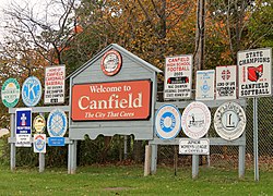
Canfield, Ohio
| Canfield, Ohio | |
|---|---|
| City | |
 |
|
 Location of Canfield, Ohio |
|
 Location of Canfield in Mahoning County |
|
| Coordinates: 41°1′47″N 80°45′56″W / 41.02972°N 80.76556°WCoordinates: 41°1′47″N 80°45′56″W / 41.02972°N 80.76556°W | |
| Country | United States |
| State | Ohio |
| County | Mahoning |
| Government | |
| • Mayor | Bernie Kosar Sr. |
| Area | |
| • Total | 4.61 sq mi (11.94 km2) |
| • Land | 4.58 sq mi (11.86 km2) |
| • Water | 0.03 sq mi (0.08 km2) |
| Elevation | 1,145 ft (349 m) |
| Population (2010) | |
| • Total | 7,515 |
| • Estimate (2012) | 7,434 |
| • Density | 1,640.8/sq mi (633.5/km2) |
| Time zone | Eastern (EST) (UTC-5) |
| • Summer (DST) | EDT (UTC-4) |
| ZIP code | 44406 |
| Area code(s) | 330 |
| FIPS code | 39-11360 |
| GNIS feature ID | 1038796 |
| Website | http://www.ci.canfield.oh.us/ |
Canfield is a suburban city located in Mahoning County, Ohio, United States, at the intersection of U.S. Route 224 and State Route 46/U.S. Route 62, about ten miles southwest of Youngstown. The population was 7,515 at the 2010 census. It is part of the Youngstown-Warren-Boardman, OH-PA Metropolitan Statistical Area. In 2005 Canfield was rated the 82nd best place to live in the United States by Money magazine.
The village was named after Judson Canfield, a land agent. Canfield was incorporated as a village in 1849.
In 1992, Canfield city residents, although surrounded completely by Canfield Township, voted to secede from the township. This motion created two separate governmental entities — one a municipality, the other a township, which continue to operate together in many respects. An example of this is mutual fire protection service, communications with each other with respect to roads and highways, and the physical assets of both (schools, parks, etc.).
According to the United States Census Bureau, the city has a total area of 4.61 square miles (11.94 km2), of which 4.58 square miles (11.86 km2) is land and 0.03 square miles (0.08 km2) is water.
As of the census of 2010, there were 7,515 people, 3,073 households, and 2,196 families residing in the city. The population density was 1,640.8 inhabitants per square mile (633.5/km2). There were 3,306 housing units at an average density of 721.8 per square mile (278.7/km2). The racial makeup of the city was 96.4% White, 0.4% African American, 0.1% Native American, 1.8% Asian, 0.5% from other races, and 0.7% from two or more races. Hispanic or Latino of any race were 1.5% of the population.
...
Wikipedia
