Caneggio
| Caneggio | ||
|---|---|---|
| Former municipality of Switzerland | ||
|
||
| Coordinates: 45°52′N 9°02′E / 45.867°N 9.033°ECoordinates: 45°52′N 9°02′E / 45.867°N 9.033°E | ||
| Country | Switzerland | |
| Canton | Ticino | |
| District | Mendrisio | |
| Government | ||
| • Mayor | Giovanni Ceracchini | |
| Area | ||
| • Total | 3.53 km2 (1.36 sq mi) | |
| Elevation | 555 m (1,821 ft) | |
| Population | ||
| • Total | 337 | |
| • Density | 95/km2 (250/sq mi) | |
| Postal code | 6837 | |
| SFOS number | 5246 | |
| Surrounded by | Bruzella, Cabbio, Castel San Pietro, Cernobbio (IT-CO), Moltrasio (IT-CO), Morbio Superiore | |
| Website | SFSO statistics |
|
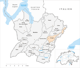
Caneggio is a former municipality in the district of Mendrisio in the canton of Ticino in Switzerland. On 25 October 2009 the municipalities of Bruzella, Cabbio, Caneggio, Morbio Superiore, Muggio, Sagno and Breggia merged into the municipality of Breggia
Caneggio is first mentioned in 1209 as Canegio. In 1335 it was mentioned as Canezio.
Roman era graves were discovered in Campora.
The village was part of the parish of Bruzella. They separated in 1649 and Caneggio, probably in the same century, joined the parish of Balerna. The church of S. Maria Assunta is first mentioned in 1566. In 1715, it was rebuilt and renovated in 1971–75.
The village had limited farming land, so the local economy was based on alpine pastures and forestry. Due to the limited land, many residents of the village emigrated to other countries. With the rise of the services sector in the second half of the 20th Century the population stabilized. The residents are now mostly commuters.
Caneggio has an area, as of 1997[update], of 3.53 square kilometers (1.36 sq mi). Of this area, 0.26 km2 (0.10 sq mi) or 7.4% is used for agricultural purposes, while 3.46 km2 (1.34 sq mi) or 98.0% is forested. Of the rest of the land, 0.2 km2 (0.077 sq mi) or 5.7% is settled (buildings or roads), 0.04 km2 (9.9 acres) or 1.1% is either rivers or lakes.
Of the built up area, housing and buildings made up 3.1% and transportation infrastructure made up 2.5%. Out of the forested land, 95.5% of the total land area is heavily forested and 2.5% is covered with orchards or small clusters of trees. Of the agricultural land, 4.2% is used for growing crops and 3.1% is used for alpine pastures. All the water in the municipality is flowing water.
...
Wikipedia


