Bruzella
| Bruzella | ||
|---|---|---|
| Former municipality of Switzerland | ||
|
||
| Coordinates: 45°53′N 9°02′E / 45.883°N 9.033°ECoordinates: 45°53′N 9°02′E / 45.883°N 9.033°E | ||
| Country | Switzerland | |
| Canton | Ticino | |
| District | Mendrisio | |
| Government | ||
| • Mayor | Luca Cavadini | |
| Area | ||
| • Total | 3.44 km2 (1.33 sq mi) | |
| Elevation | 593 m (1,946 ft) | |
| Population | ||
| • Total | 185 | |
| • Density | 54/km2 (140/sq mi) | |
| Postal code | 6837 | |
| SFOS number | 5244 | |
| Surrounded by | Cabbio, Caneggio, Castel San Pietro, Moltrasio (IT-CO), Schignano (IT-CO) | |
| Website | SFSO statistics |
|
Bruzella was a municipality in the district of Mendrisio in the canton of Ticino in Switzerland. On 25 October 2009 the municipalities of Bruzella, Cabbio, Caneggio, Morbio Superiore, Muggio and Sagno merged into the municipality of Breggia.
Bruzella is first mentioned in 852 as Brusella. Until 1609 it was united territorially with Monte and until 1649 it was part of the parish of Caneggio. The Church of S. Siro is first mentioned in 1579. It was rebuilt in the 18th century, and restored in 1973.
Traditionally, cheese production and forestry (production of timber and charcoal) were the main economic sources. This was supplemented by periodic waves of emigration. By 1985, agriculture only employed six people. At the beginning of the 21st century, the population was largely made of retirees and commuters.
The blazon of the municipal coat of arms is Quartered: 1st Argent two pales azure, 2nd Gules a cross argent, 3rd Gules an oak branch with an acorn or in bend and 4th Bendy of six argent and azure.
Bruzella has an area, as of 1997[update], of 3.44 square kilometers (1.33 sq mi). Of this area, 0.35 km2 (0.14 sq mi) or 10.2% is used for agricultural purposes, while 3 km2 (1.2 sq mi) or 87.2% is forested. Of the rest of the land, 0.06 km2 (15 acres) or 1.7% is settled (buildings or roads) and 0.03 km2 (7.4 acres) or 0.9% is unproductive land.
Of the built up area, housing and buildings made up 0.6% and transportation infrastructure made up 1.2%. Out of the forested land, 83.4% of the total land area is heavily forested and 3.8% is covered with orchards or small clusters of trees. Of the agricultural land, 9.6% is used for growing crops.
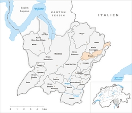
The village is located in the Mendrisio district on a terrace along the left side of the Valle di Muggio
...
Wikipedia


