Candlestick Park Tornado
| F5 tornado | |
|---|---|

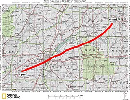
Official track of the tornado through central Mississippi
|
|
| Formed | March 3, 1966 4:00 p.m. – 7:45 p.m. CST |
| Max rating1 | F5 tornado |
| Damage | $17.9 million (1966 USD) $132 million (2017 USD) |
| Casualties | 58 fatalities, 518 injuries |
| Areas affected | Hinds, Rankin, Scott, Leake, Neshoba, Kemper counties in Mississippi and Pickens, Tuscaloosa counties in Alabama |
| 1Most severe tornado damage; see Fujita scale | |
On March 3, 1966, a violent F5 tornado, dubbed the Candlestick Park tornado after the name of a Jackson, Mississippi shopping mall which was leveled by the storm, wrought catastrophic damage in Mississippi and Alabama along a 202.5 mi (325.9 km) track. The tornado first touched down in Hinds County, Mississippi around 4:00 p.m. CST and moved towards northeast before dissipating at 7:45 p.m. CST in Tuscaloosa County, Alabama.
On March 3, 1966, the atmosphere over Mississippi was ripe for a violent tornado. In the upper-levels of the troposphere, a fairly strong jet stream, with winds estimated at 140 to 150 mph (230 to 240 km/h), oriented itself northeastward over the state, providing strong diffluence. A large mid-level trough, centered near Sioux Falls, South Dakota, was the overall system that produced the tornado. It featured low millibar heights roughly four times below the standard mean. Additionally, an unusually strong mid-level jet stream with 105 mph (169 km/h) winds provided additional energy to the storm system. The final factor in the development of the Candlestick Park storm was a subtle wind shift near the surface. At the higher levels, winds flowed from the southwest to the northeast in relation to the jet stream; however, closer to the surface, the inflow from the low pressure system over South Dakota resulted in a south to north flow, allowing for rotation within storms.
In the hours prior to the tornado forming, convective available potential energy (CAPE) values of 1554 j/kg were present, indicating significant instability. However, dry air at higher levels created a capping inversion, limiting the number of thunderstorms that could develop. Later on, a warm front moved passed Jackson, Mississippi, allowing more moist air into the region and increasing lapse rates. This cap served to prevent a tornado outbreak but allowed the formation of a few discrete strong storms. With this, a supercell thunderstorm developed over central Mississippi and produced a large tornado around 4:00 pm CST near the old Adams community in Hinds County, several miles south-southwest of Raymond.
...
Wikipedia
