Canadian shield
| Canadian Shield Stratigraphic range: Precambrian |
|
|---|---|
| Type | Shield |
| Unit of | North American craton |
| Sub-units |
Laurentian Upland Kazan |
| Area | 8 000 000 km2 |
| Location | |
| Region | North America |
| Country |
|
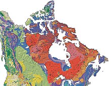
 The Canadian Shield is a broad region of Precambrian rock (pictured in shades of red) that encircles Hudson Bay. It spans Eastern, Northeastern, and East-central Canada and the Northern portion of the upper midwestern United States. |
|
The Canadian Shield, also called the Laurentian Plateau, or Bouclier canadien (French), is a large area of exposed Precambrian igneous and high-grade metamorphic rocks (geological shield) that forms the ancient geological core of the North American continent (the North American Craton or Laurentia). Composed of igneous rock resulting from its long volcanic history, the area is covered by a thin layer of soil. With a deep, common, joined bedrock region in eastern and central Canada, it stretches north from the Great Lakes to the Arctic Ocean, covering over half of Canada; it also extends south into the northern reaches of the United States. Human population is sparse, and industrial development is minimal, while mining is prevalent.
The Canadian Shield is a physiographic division, consisting of five smaller, physiographic provinces: the Laurentian Upland, Kazan Region, Davis, Hudson and James. The shield extends into the United States as the Adirondack Mountains (connected by the Frontenac Axis) and the Superior Upland. The Canadian Shield is U-shaped and is a subsection of the Laurentia craton signifying the area of greatest glacial impact (scraping down to bare rock) creating the thin soils. The Canadian Shield is more than 3.96 billion years old. The Canadian Shield once had jagged peaks, higher than any of today's mountains, but millions of years of erosion have changed these mountains to rolling hills.
...
Wikipedia
