Campo, Colorado
| Campo, Colorado | |
|---|---|
| Statutory Town | |

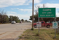
Entering Campo from the north on U.S. Route 287/385.
|
|
 Location within Baca County and Colorado |
|
| Coordinates: 37°06′17″N 102°34′44″W / 37.104711°N 102.578798°WCoordinates: 37°06′17″N 102°34′44″W / 37.104711°N 102.578798°W | |
| Country |
|
| State |
|
| County | Baca County |
| Incorporated | March 6, 1950 |
| Government | |
| • Type | Statutory Town |
| Area | |
| • Total | 0.1 sq mi (0.4 km2) |
| • Land | 0.1 sq mi (0.4 km2) |
| • Water | 0 sq mi (0 km2) |
| Elevation | 4,344 ft (1,324 m) |
| Population (2010) | |
| • Total | 109 |
| • Density | 1,100/sq mi (270/km2) |
| Time zone | MST (UTC-7) |
| • Summer (DST) | MDT (UTC-6) |
| ZIP code | 81029 |
| Area code(s) | 719 |
| INCITS place code | 0811645 |
| GNIS feature ID | 0196360 |
Campo is a Statutory Town located in Baca County, Colorado, United States. The town population was 109 at the 2010 United States Census. The town is situated on the Great Plains, straddling U.S. Route 287/385.
A post office called Campo was established in 1913. Campo is a name derived from Spanish meaning "field".
Campo is located just north of the Oklahoma border in southern Baca County at 37°06′17″N 102°34′42″W / 37.104731°N 102.578394°W. Via U.S. Route 287/385 it is 21 miles (34 km) north to Springfield, the county seat, and 27 miles (43 km) south to Boise City, Oklahoma.
According to the United States Census Bureau, the town has a total area of 0.1 square miles (0.26 km2), all of it land.
A long lived EF2 tornado brushed the south side of Campo, Colorado on May 31, 2010.
As of the census of 2000, there were 150 people, 55 households, and 44 families residing in the town. The population density was 1,086.4 people per square mile (413.7/km²). There were 79 housing units at an average density of 572.2 per square mile (217.9/km²). The racial makeup of the town was 95.33% White, 3.33% Native American, and 1.33% from two or more races. Hispanic or Latino of any race were 4.67% of the population.
...
Wikipedia
