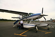
Campbell River Airport
| Campbell River Airport | |||||||||||||||
|---|---|---|---|---|---|---|---|---|---|---|---|---|---|---|---|
 |
|||||||||||||||
| Summary | |||||||||||||||
| Airport type | Public | ||||||||||||||
| Owner/Operator | District of Campbell River | ||||||||||||||
| Location | Campbell River, British Columbia | ||||||||||||||
| Time zone | PST (UTC−08:00) | ||||||||||||||
| • Summer (DST) | PDT (UTC−07:00) | ||||||||||||||
| Elevation AMSL | 357 ft / 109 m | ||||||||||||||
| Coordinates | 49°57′07″N 125°16′23″W / 49.95194°N 125.27306°WCoordinates: 49°57′07″N 125°16′23″W / 49.95194°N 125.27306°W | ||||||||||||||
| Website | www.crairport.ca | ||||||||||||||
| Map | |||||||||||||||
| Location in British Columbia | |||||||||||||||
| Runways | |||||||||||||||
|
|||||||||||||||
| Helipads | |||||||||||||||
|
|||||||||||||||
| Statistics (2010) | |||||||||||||||
|
|||||||||||||||
|
Source: Canada Flight Supplement and Transport Canada
Environment Canada Movements from Statistics Canada |
|||||||||||||||
| Aircraft movements | 30,604 |
|---|
Campbell River Airport (IATA: YBL, ICAO: CYBL) is located 4.5 nautical miles (8.3 km; 5.2 mi) south of the town of Campbell River, British Columbia, Canada.
The airport is classified as an airport of entry by Nav Canada and is staffed by the Canada Border Services Agency. CBSA officers at this airport currently can handle general aviation aircraft only, with no more than 15 passengers.
...
Wikipedia

