Campbell, Ohio
| Campbell, Ohio | |
|---|---|
| City | |

Houses on Jackson Street
|
|
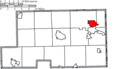
 Location of Campbell, Ohio |
|
 Location of Campbell in Mahoning County |
|
| Coordinates: 41°4′38″N 80°35′26″W / 41.07722°N 80.59056°W | |
| Country | United States |
| State | Ohio |
| County | Mahoning |
| Government | |
| • Mayor | Nick Phillips |
| Area | |
| • Total | 3.74 sq mi (9.69 km2) |
| • Land | 3.71 sq mi (9.61 km2) |
| • Water | 0.03 sq mi (0.08 km2) |
| Elevation | 1,030 ft (314 m) |
| Population (2010) | |
| • Total | 8,235 |
| • Estimate (2012) | 8,123 |
| • Density | 2,219.7/sq mi (857.0/km2) |
| Time zone | Eastern (EST) (UTC-5) |
| • Summer (DST) | EDT (UTC-4) |
| ZIP code | 44405 |
| Area code(s) | 330 |
| FIPS code | 39-11066 |
| GNIS feature ID | 1056760 |
| Website | http://www.campbellohio.gov/ |
Campbell (/ˈkæməl/;KAM-ǝl) is a city in Mahoning County, Ohio, United States. The population was 8,235 at the 2010 census. It is part of the Youngstown-Warren-Boardman, OH-PA Metropolitan Statistical Area.
Campbell was formerly known as the village of East Youngstown, and this designation still appears on real estate deeds for the city. In 1926, the city was renamed for local industrialist James A. Campbell, then chairman of the Youngstown Sheet and Tube Company. A major destination for immigrants from Southern and Eastern Europe, Campbell is sometimes referred to as the "City of Churches," because of the wide variety of religious structures found throughout the community.
Campbell is located at 41°4′38″N 80°35′26″W / 41.07722°N 80.59056°WCoordinates: 41°4′38″N 80°35′26″W / 41.07722°N 80.59056°W.
...
Wikipedia
