Camden Hills State Park
| Camden Hills State Park | |
| Maine State Park | |
|
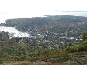
Camden from the summit of Mount Battie
|
|
| Country | |
|---|---|
| State | |
| Counties | Knox, Waldo |
| Towns | Camden, Lincolnville |
| Elevation | 259 ft (79 m) |
| Coordinates | 44°16′56″N 69°02′20″W / 44.28222°N 69.03889°WCoordinates: 44°16′56″N 69°02′20″W / 44.28222°N 69.03889°W |
| Highest point | Mount Megunticook |
| - elevation | 1,365 ft (416 m) |
| - coordinates | 44°14′29″N 69°04′04″W / 44.24139°N 69.06778°W |
| Area | 5,710 acres (2,311 ha) |
| Established | Unspecified |
| Management | Maine Department of Agriculture, Conservation and Forestry |
| Website: Camden Hills State Park | |
Camden Hills State Park is a publicly owned recreation area overlooking Penobscot Bay in the town of Camden in Knox County, Maine. The state park covers 5,710 acres (2,310 ha) including Mount Battie, with an elevation of nearly 800 feet (240 m), and 1,385-foot-high (422 m) Mount Megunticook, the tallest peak in the park. In addition to trails for hiking, horseback riding, mountain biking, cross-country skiing, snowmobiling, and snowshoeing, the park also offers opportunities for hunting and camping.
...
Wikipedia

