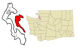
Camano Island, Washington
| Camano Island, Washington | |
|---|---|
| CDP | |
 Location of Camano, Washington |
|
| Coordinates: 48°11′37″N 122°29′11″W / 48.19361°N 122.48639°WCoordinates: 48°11′37″N 122°29′11″W / 48.19361°N 122.48639°W | |
| Country | United States |
| State | Washington |
| County | Island |
| Area | |
| • Total | 94.9 sq mi (245.9 km2) |
| • Land | 39.8 sq mi (103.0 km2) |
| • Water | 55.2 sq mi (142.9 km2) |
| Elevation | 52 ft (16 m) |
| Population (2010) | |
| • Total | 15,661 |
| • Density | 335.6/sq mi (129.6/km2) |
| Time zone | Pacific (PST) (UTC-8) |
| • Summer (DST) | PDT (UTC-7) |
| FIPS code | 53-09365 |
| GNIS feature ID | 1503722 |
| Highways |
|
Camano is a census-designated place (CDP) in Island County, Washington, United States. The population was 13,347 at the 2000 census. Camano is coterminous with the namesake island on which it sits. Camano (as Camano Island) has its own ZIP code (98282) but shares a post office with Stanwood, despite Stanwood's distance. Based on per capita income, one of the more reliable measures of affluence, Camano ranks 99th of 522 areas in the state of Washington to be ranked.
Camano is located at 48°11′37″N 122°29′11″W / 48.19361°N 122.48639°W (48.193606, -122.486419).
According to the United States Census Bureau, the CDP has a total area of 94.9 square miles (245.9 km²), of which, 39.8 square miles (103.0 km²) of it is land and 55.2 square miles (142.9 km²) of it (58.11%) is water.
As of the census of 2000, there were 13,347 people, 5,357 households, and 4,028 families residing in the Camano Island CDP. The population density was 335.6 people per square mile (129.6/km²). There were 6,709 housing units at an average density of 168.7/sq mi (65.1/km²). The racial makeup of the CDP was 95.61% White, 0.25% African American, 0.83% Native American, 0.65% Asian, 0.25% Pacific Islander, 0.56% from other races, and 1.84% from two or more races. Hispanic or Latino of any race were 2.06% of the population.
...
Wikipedia
