California Central Valley grasslands
| Central Valley | |
|---|---|
| Great Central Valley, Great Valley, The Valley, and the Golden Empire | |

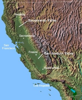
Topography, major parts and cities of the Central Valley
|
|
| Location | California, United States |
| Long-axis length | 450 mi (720 km) |
| Width | 40 to 60 mi (64 to 97 km) |
| Area | 18,000 sq mi (47,000 km2) |
| Depth | 2,000 to 6,000 ft (610 to 1,830 m) |
| Geology | |
| Type | Alluvial |
| Age | 2-3 million years |
| Geography | |
| Bounded by | Sierra Nevada (east), Cascade Range, Klamath Mountains (north), Coast Range, San Francisco Bay (west), Tehachapi Mountains (south) |
| Coordinates | 40°12′N 122°12′W / 40.200°N 122.200°WCoordinates: 40°12′N 122°12′W / 40.200°N 122.200°W |
| Population centers | Redding, Chico, Yuba City, Sacramento, , Porterville, Modesto, Turlock, Merced, Fresno, Visalia, Bakersfield, Clovis |
| Traversed by | Interstate 5, Interstate 80, State Route 99 |
| Watercourses | Sacramento River, San Joaquin River, Kings River |
The Central Valley is a flat valley that dominates the geographical center of the U.S. state of California. It is 40 to 60 miles (60 to 100 km) wide and stretches approximately 450 miles (720 km) from north-northwest to south-southeast, inland from and parallel to the Pacific Ocean coast. It covers approximately 18,000 square miles (47,000 km2), about 11% of California's total land area (or about the size of Denmark). The valley is bounded by the Sierra Nevada to the east and the Coast Ranges to the west.
It is California's single most productive agricultural region and one of the most productive in the world, providing more than half of the fruits, vegetables and nuts grown in the United States. More than 7 million acres (28,000 km2) of the valley are irrigated via an extensive system of reservoirs and canals. The valley also has many major cities, including the state capital Sacramento; as well as Redding, , Modesto, Fresno and Bakersfield.
The Central Valley watershed comprises 60,000 square miles (160,000 km2), or over a third of California. Its three main drainage systems are the Sacramento Valley in the north, which receives well over 20 inches (510 mm) of rain annually; the drier San Joaquin Valley in the south, and the Tulare Basin and its semi-arid desert climate at the southernmost end. The Sacramento and San Joaquin river systems drain their respective valleys and meet to form the Sacramento-San Joaquin River Delta, a large expanse of interconnected canals, stream beds, sloughs, marshes and peat islands. The delta empties into the San Francisco Bay, and then ultimately flows into the Pacific. The waters of the Tulare Basin essentially never flow to the ocean (with the exception of Kings River waters diverted northward for irrigation), though they are connected by man-made canals to the San Joaquin and could drain there again naturally if they were ever to rise high enough.
...
Wikipedia
