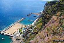
Calheta, Madeira
| Calheta | |||
| Municipality (Concelho) | |||
|
|||
| Official name: Concelho da Calheta (Madeira) | |||
| Name origin: Portuguese for small bay | |||
| Nickname: | |||
| Country | |||
|---|---|---|---|
| Autonomous Region | |||
| Island | Madeira | ||
| Civil Parishes | Arco da Calheta, Calheta, Estreito da Calheta, Fajã da Ovelha, Jardim do Mar, Paul do Mar, Ponta do Pargo, Prazeres | ||
| Coordinates | 32°43′33″N 17°9′57″W / 32.72583°N 17.16583°WCoordinates: 32°43′33″N 17°9′57″W / 32.72583°N 17.16583°W | ||
| Highest point | |||
| - elevation | 1,640 m (5,381 ft) | ||
| Lowest point | |||
| - elevation | 0 m (0 ft) | ||
| Area | 111.50 km2 (43 sq mi) | ||
| Population | 11,521 (2011) | ||
| Density | 103/km2 (267/sq mi) | ||
| Settlement | 1 July 1502 | ||
| - Municipality | c. 1835 | ||
| LAU | Câmara Municipal | ||
| - location | Avenida Dom Manuel I | ||
| - elevation | 35 m (115 ft) | ||
| - coordinates | 32°43′17″N 17°10′40″W / 32.72139°N 17.17778°W | ||
| President | Carlos Teles (PPD-PSD) | ||
| Municipal Chair | Manuel Baeta de Castro | ||
| Timezone | WET (UTC0) | ||
| - summer (DST) | WEST (UTC+1) | ||
| Postal Zone | 9370-135 | ||
| Area Code & Prefix | (+351) 291 XXX XXX | ||
| Demonym | Calhetense | ||
| Patron Saint | Espírito Santo | ||
| Municipal Holidays | 24 June | ||
|
Administrative location of Calheta in the archipelago of Madeira
|
|||
| Website: http://www.cm-calheta-madeira.com/ | |||
| Statistics from INE (2001); geographic detail from Instituto Geográfico Português (2010) | |||
Calheta (Portuguese pronunciation: [kɐˈʎetɐ]) is a municipality on the southwest coast of Madeira, Portugal. The population in 2011 was 11,521, in an area of 111.50 km².
The origin of the areas name, are both related to the toponymy of Calheta (which means "small bay" in Portuguese): first, that there existed a small bay or cove, which already had this name, but secondly, that the area of the settlement was the off-port for sugar and collection of wood. Calheta was founded in 1430; the parish, of the same name (which is the central part of the municipality) is one of the oldest parishes on the island of Madeira, and one of the first to be explored by the early settlers. It was the area selected by João Gonçalves Zarco (the island's discoverer) as a grant to his son and his wife, João Gonçalves da Câmara and Beatriz Gonçalves.
The village became a town 72 years after its foundation, on 1 July 1502, after a royal foral (charter) was granted by King Manuel I. The region was primarily settled by noblemen and knights, influencing the toponomic names that appeared in many of its localities: such as Lombo do Doutor and Lombo do Atouguia. In 1502, João de França constructed the Chapel of Nossa Senhora da Graça (English: Our Lady of Grace), which was to be the basis for the new parish of Calheta, founding the first and oldest institutions of the parish. Similarly, the Santa Casa da Misericórdia was established in 1535, to serve the elderly and provide healthcare for the local residents.
The parish of Prazeres, which was an ecclesiastical component of Estreito da Calheta was dismembered in 1733, becoming an autonomous clergy on 12 November (which was later followed by the first cornerstone of the Church of Prazeres, in 1751). The Liberal revolution resulted in the incorporation of Calheta as municipality in 1835. Similarly, the parish of Ponta do Pargo, after several years being part of the municipality of Porto Moniz (between 1835 and 1849), began to function as an administrative unit of the municipality of Calheta after the latter municipal seat was disincorporated. The restoration of Porto Moniz in 1855, resulted in the parishes reincorporation within the borders of Porto Moniz. By law, on 26 June 1871, was reintegrated into Ponta do Pargo.
...
Wikipedia


