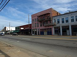
Calera, AL
| Calera | |
|---|---|
| City | |
| Calera, Alabama | |

The Calera Downtown Historic District was listed on the National Register of Historic Places on March 29, 2006.
|
|
 Location of Calera in Chilton County and Shelby County, Alabama. |
|
| Location in the United States | |
| Coordinates: 33°06′10″N 86°45′13″W / 33.10278°N 86.75361°WCoordinates: 33°06′10″N 86°45′13″W / 33.10278°N 86.75361°W | |
| Country | United States |
| State | Alabama |
| Counties | Chilton, Shelby |
| Area | |
| • Total | 24.35 sq mi (63.06 km2) |
| • Land | 24.08 sq mi (62.38 km2) |
| • Water | 0.27 sq mi (0.69 km2) |
| Population (2010) | |
| • Total | 11,620 |
| • Estimate (2016) | 13,489 |
| • Density | 560.08/sq mi (216.25/km2) |
| Time zone | CST (UTC-6) |
| • Summer (DST) | CDT (UTC-5) |
| ZIP code | 35040 |
| Area code(s) | 205 |
| FIPS code | 01-11416 |
| Website | www |
Calera is a city in Shelby and Chilton counties in the U.S. state of Alabama. It is the location of the Shelby County Airport. Calera's population was 3,158 at the 2000 census.
As of the 2010 census the population had more than tripled to 11,620, making it the fastest-growing city in Alabama. It is within the Birmingham-Hoover, Alabama Metropolitan Statistical Area and positively affected by the growth in its economy.
Calera is located in southern Shelby County at 33°06′27″N 86°45′00″W / 33.107572°N 86.749964°W. The city limits extend southward into Chilton County along U.S. Route 31, the main highway through the city. Interstate 65 passes through the eastern side of the city, with access from exits 228, 231, and 234.
According to the United States Census Bureau, the city has a total area of 24.4 square miles (63.1 km2), of which 24.1 square miles (62.4 km2) is land and 0.27 square miles (0.7 km2), or 1.17%, is water.
The city of Calera was incorporated in 1887, and named after the Spanish word for "limestone" for all of the limestone deposits located in the area.
...
Wikipedia

