Caledonia, Ohio
| Caledonia, Ohio | |
|---|---|
| Village | |

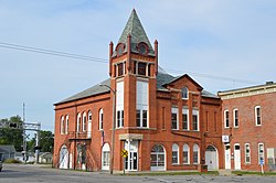
Town hall on the public square
|
|
 Location of Caledonia, Ohio |
|
 Location of Caledonia in Marion County |
|
| Coordinates: 40°38′10″N 82°58′9″W / 40.63611°N 82.96917°WCoordinates: 40°38′10″N 82°58′9″W / 40.63611°N 82.96917°W | |
| Country | United States |
| State | Ohio |
| County | Marion |
| Area | |
| • Total | 0.23 sq mi (0.60 km2) |
| • Land | 0.23 sq mi (0.60 km2) |
| • Water | 0 sq mi (0 km2) |
| Elevation | 994 ft (303 m) |
| Population (2010) | |
| • Total | 577 |
| • Estimate (2012) | 565 |
| • Density | 2,508.7/sq mi (968.6/km2) |
| Time zone | Eastern (EST) (UTC-5) |
| • Summer (DST) | EDT (UTC-4) |
| ZIP code | 43314 |
| Area code(s) | 419 |
| FIPS code | 39-10954 |
| GNIS feature ID | 1056754 |
| Website | http://www.caledonia-village.com |
Caledonia is a village in Marion County, Ohio, United States. The population was 577 at the 2010 census.
The village was named after Caledonia, an ancient name for Scotland, the ancestral home of a large share of the first settlers.
The northern side of Caledonia is the location of the Caledonia Bowstring Bridge, which is listed on the National Register of Historic Places.
Caledonia is located at 40°38′10″N 82°58′9″W / 40.63611°N 82.96917°W (40.636068, -82.969301).
According to the United States Census Bureau, the village has a total area of 0.23 square miles (0.60 km2), all land.
As of the census of 2010, there were 577 people, 232 households, and 174 families residing in the village. The population density was 2,508.7 inhabitants per square mile (968.6/km2). There were 260 housing units at an average density of 1,130.4 per square mile (436.4/km2). The racial makeup of the village was 97.4% White, 1.6% African American, 0.2% Asian, 0.7% from other races, and 0.2% from two or more races. Hispanic or Latino of any race were 0.5% of the population.
...
Wikipedia
