Calderwood, Tennessee
|
Calderwood Hydroelectric Development
|
|

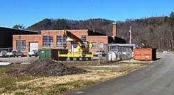
Calderwood Dam service building
|
|
| Location | 314 Growdon Boulevard |
|---|---|
| Nearest city | Maryville, Tennessee |
| Coordinates | 35°29′56″N 83°59′15″W / 35.49889°N 83.98750°WCoordinates: 35°29′56″N 83°59′15″W / 35.49889°N 83.98750°W |
| Area | 195 acres (79 ha) |
| Built | 1930–1953 |
| Architect | A.V. Karpov, Tapoco Inc. |
| Architectural style | Colonial Revival |
| NRHP Reference # | 04000545 |
| Added to NRHP | May 24, 2004 |
Calderwood was a community once located along the Little Tennessee River in Blount County, Tennessee, United States. Established in 1912 as a base for the Aluminum Company of America's Little Tennessee Valley hydroelectric development operations, the community continued to house construction personnel and dam maintenance personnel for nearby Calderwood Dam until the 1960s. Although the community's houses were razed after its abandonment, three buildings located in the community— the Calderwood Dam service building, the Calderwood School, and a Quonset hut used as a theater— were included in a supplementary listing for Calderwood Dam on the National Register of Historic Places in 2004.
Alcoa began developing the Little Tennessee Valley in 1909 to provide the ample amounts of electricity necessary to power its planned aluminum smelting operations in Blount County. Under the leadership of Alcoa engineer Isaac Glidden Calderwood (1871–1941), three dams— Cheoah (1919), Santeetlah (1928), and Calderwood (1930)— were completed in a remote section of the valley along the Tennessee-North Carolina border. The community of Calderwood was initially known as "Alcoa," but was renamed in I. G. Calderwood's honor after the company reapplied the name "Alcoa" to its main company town in northern Blount County.
The Calderwood community was situated on the north bank (or Blount County side) of the Little Tennessee River, approximately 41 miles (66 km) upstream from the mouth of the river. This section of the river is technically part of Chilhowee Lake, which is impounded by Chilhowee Dam approximately 8 miles (13 km) downstream. Calderwood Dam is located 3 miles (4.8 km) upstream, on the opposite end of a horseshoe bend in the river. U.S. Route 129 provides the only major road access to the Calderwood area. Just past Calderwood, US-129 enters a switchback-laden stretch of road known as "The Dragon," which is popular with motorcyclists.
The surviving community structures and the Calderwood Dam service building are accessible via Housley Road, which connects US-129 with Growdon Road on the riverfront. The Calderwood Baptist Church is located about halfway down Housley Road in a wooded area on the left. At the intersection of Housley and Growdon, the service building is to the left, with a gated road (open to foot traffic) continuing to the powerhouse. To the right of the intersection, the road continues past the Calderwood School building and culminates at a boat ramp in the lake connected via causeway to the mainland. Just past the school building, an unmarked road leads up the cliffslope to the Calderwood Methodist Church and the former residential area.
...
Wikipedia


