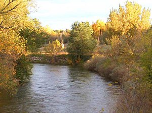
Cache La Poudre River
| Cache la Poudre River | |
| River | |
|
Cache La Poudre River as it flows through Fort Collins, Colorado.
|
|
| Country | United States |
|---|---|
| State | Colorado |
| Tributaries | |
| - left | North Fork Cache la Poudre River |
| - right | South Fork Cache la Poudre River |
| Cities | Fort Collins, Greeley |
| Source | Rocky Mountains |
| - location | Rocky Mountain National Park |
| - elevation | 10,755 ft (3,278 m) |
| - coordinates | 40°25′29″N 105°48′24″W / 40.42472°N 105.80667°W |
| Mouth | South Platte River |
| - location | Near Greeley |
| - elevation | 4,600 ft (1,402 m) |
| - coordinates | 40°25′17″N 104°36′3″W / 40.42139°N 104.60083°WCoordinates: 40°25′17″N 104°36′3″W / 40.42139°N 104.60083°W |
| Length | 126 mi (203 km) |
| Discharge | for Fort Collins |
| - average | 162 cu ft/s (4.6 m3/s) |
| - max | 6,080 cu ft/s (172.2 m3/s) |
| - min | 0 cu ft/s (0.0 m3/s) |
The Cache la Poudre River (![]() i/ˌkæʃ ləˈpuːdər/), also known as the Poudre River, is a river in the state of Colorado in the United States.
i/ˌkæʃ ləˈpuːdər/), also known as the Poudre River, is a river in the state of Colorado in the United States.
The name of the river (French for "Hide the Powder") is a corruption of the original Cache à la Poudre or "cache of powder". It refers to an incident in the 1820s when French trappers, caught by a snowstorm, were forced to bury part of their gunpowder along the banks of the river.
Its headwaters are in the Front Range in Larimer County, in the northern part of Rocky Mountain National Park. The river descends eastward in the mountains through the Roosevelt National Forest in Poudre Canyon. It emerges from the foothills north of the city of Fort Collins.
...
Wikipedia

